Home > Europe > United Kingdom > England > London > Museums > National Maritime Museum
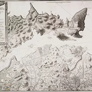
The Port of Mahon and surrounding area, from Cala Murte to Cala Rafalet, 1786 (engraving)
")
![]()
Wall Art and Photo Gifts from Fine Art Finder
The Port of Mahon and surrounding area, from Cala Murte to Cala Rafalet, 1786 (engraving)
7339376 The Port of Mahon and surrounding area, from Cala Murte to Cala Rafalet, 1786 (engraving) by Salvador Carmona, Manuel (1734-1820); 63x99 cm; National Maritime Museum, London, UK; (add.info.: Creator: Anonymous;s Drouet; Manuel Salvador Carmona
Single sheet. Engr. Scale: [ca.1:2 000 (bar)]. Cartographic Note: North at 310 degrees. Ungraduated. Rhumb lines. Soundings. Additional Places: Minorca. Contents Note: Key within title cartouche. Inscribed 'El puerto de Mahon y su costa, desde Cala Murte hasta Cala Rafalet. Ruinas del Castillo de Sn. Felipe, baterias existentes y los campamentos, trincheras, y baterias del ultimo sitio. Gravado el ano de 1786.'); © National Maritime Museum, Greenwich, London
Media ID 38286196
© © National Maritime Museum, Greenwich, London / Bridgeman Images
Boat Dock Harbor Area Harbour Area Harbours Port Area
FEATURES IN THESE COLLECTIONS
> Animals
> Insects
> Hemiptera
> Black Scale
> Arts
> Artists
> S
> Manuel Salvador Carmona
> Europe
> United Kingdom
> England
> London
> Boroughs
> Greenwich
> Europe
> United Kingdom
> England
> London
> Museums
> Greenwich Heritage Centre
> Europe
> United Kingdom
> England
> London
> Museums
> National Maritime Museum
> Europe
> United Kingdom
> England
> London
> Towns
> Greenwich
> Europe
> United Kingdom
> Heritage Sites
> Maritime Greenwich
> Europe
> United Kingdom
> Maps
> Fine Art Finder
> Artists
> British School
> Fine Art Finder
> Artists
> Manuel Salvador Carmona
> Maps and Charts
> Early Maps
EDITORS COMMENTS
This stunning engraving captures the beauty and history of The Port of Mahon and its surrounding area in 1786. From Cala Murte to Cala Rafalet, every detail is meticulously depicted by Salvador Carmona and Manuel Drouet. The intricate lines and shading bring to life the ruins of Castillo de San Felipe, existing batteries, campsites, trenches, and batteries from the last siege.
The key within the title cartouche provides a guide to understanding this historical map, inscribed with detailed descriptions of each feature portrayed. The scale of approximately 1:2,000 allows for a comprehensive view of Minorca's coastline during this period.
As you gaze upon this engraving from the National Maritime Museum in London, you are transported back in time to witness the strategic importance and natural beauty of one of Spain's most significant ports. The north direction at 310 degrees adds authenticity to this piece of cartographic artistry.
This black-and-white image not only serves as a visual representation but also as a historical document that showcases the skill and precision required in creating maps during the 18th century. It is a testament to the craftsmanship and dedication put into preserving our past for future generations to appreciate.
MADE IN THE USA
Safe Shipping with 30 Day Money Back Guarantee
FREE PERSONALISATION*
We are proud to offer a range of customisation features including Personalised Captions, Color Filters and Picture Zoom Tools
SECURE PAYMENTS
We happily accept a wide range of payment options so you can pay for the things you need in the way that is most convenient for you
* Options may vary by product and licensing agreement. Zoomed Pictures can be adjusted in the Cart.