Home > Asia > Georgia > Maps
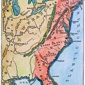
The Colonies of North America at the Declaration of Independence (colour litho)
")
![]()
Wall Art and Photo Gifts from Fine Art Finder
The Colonies of North America at the Declaration of Independence (colour litho)
PNP468338 The Colonies of North America at the Declaration of Independence (colour litho) by Stanford, Edward (1827-1904); Private Collection; (add.info.: The Continental Congress of the thirteen American colonies declared themselves to be independent from the British Empire on 4th July 1776; Map published by Stanfords Geographical Establishment, London; ); Peter Newark Pictures; English, out of copyright
Media ID 23489452
© Peter Newark Pictures / Bridgeman Images
1776 Atlas Atlases British Empire Colony Connecticut Declaration Of Independence Declaration Of Independence Usa Delaware Georgia Kentucky Maryland Massachusetts New Hampshire New Jersey North Carolina Pennsylvania Revolutionary War Rhode Island South Carolina Thirteen Virginia America Continent
FEATURES IN THESE COLLECTIONS
> Asia
> Georgia
> Related Images
> Europe
> United Kingdom
> England
> Hampshire
> Related Images
> Fine Art Finder
> Artists
> English School
> Fine Art Finder
> Maps (celestial & Terrestrial)
> Historic
> Colonial America illustrations
> American colonies
> Historic
> Colonial America illustrations
> Colonial America
> Historic
> Colonial history
> Colonial art and artists
> Maps and Charts
> British Empire Maps
> Maps and Charts
> Early Maps
EDITORS COMMENTS
This print titled "The Colonies of North America at the Declaration of Independence" takes us back to a crucial moment in history. Painted by Edward Stanford, this colour lithograph showcases the thirteen American colonies that declared their independence from the British Empire on July 4th, 1776. Published by Stanfords Geographical Establishment in London, this map provides a visual representation of the colonies during this significant period. From Virginia to Massachusetts and from New York to Georgia, each colony is meticulously depicted with its own distinct borders and details. As we observe this historic map, we are reminded of the courage and determination displayed by these early Americans who sought freedom from colonial rule. The Revolutionary War loomed large as they embarked on an arduous journey towards self-governance. This image not only serves as a reminder of our nation's birth but also highlights the importance of unity among diverse states. It symbolizes how these individual colonies came together under one common purpose – to establish a new nation built upon principles such as liberty and equality. With its vibrant colors and intricate details, this print captures both the beauty and complexity of America's past. It stands as a testament to our rich history while inspiring us to reflect on the values that continue to shape our present-day society.
MADE IN THE USA
Safe Shipping with 30 Day Money Back Guarantee
FREE PERSONALISATION*
We are proud to offer a range of customisation features including Personalised Captions, Color Filters and Picture Zoom Tools
SECURE PAYMENTS
We happily accept a wide range of payment options so you can pay for the things you need in the way that is most convenient for you
* Options may vary by product and licensing agreement. Zoomed Pictures can be adjusted in the Cart.