Home > Africa > Zimbabwe > Rhodesia
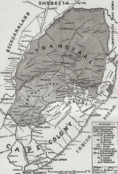
Map of the Boer Republics at the end of the 19th century, from South Africa and the Transvaal War: Vol. 1 by Louis Creswicke, published 1900 (litho)
![]()

Wall Art and Photo Gifts from Fine Art Finder
Map of the Boer Republics at the end of the 19th century, from South Africa and the Transvaal War: Vol. 1 by Louis Creswicke, published 1900 (litho)
KW371000 Map of the Boer Republics at the end of the 19th century, from South Africa and the Transvaal War: Vol. 1 by Louis Creswicke, published 1900 (litho) by English School, (20th century); Private Collection; (add.info.: Transvaal War fought from 16th December 1880 until 23rd March 1881;)
Media ID 32191736
© Bridgeman Images
FEATURES IN THESE COLLECTIONS
> Africa
> South Africa
> Maps
> Africa
> South Africa
> Related Images
> Africa
> Zimbabwe
> Rhodesia
> Fine Art Finder
> Artists
> English School
> Fine Art Finder
> Maps (celestial & Terrestrial)
> Maps and Charts
> Related Images
EDITORS COMMENTS
This lithograph, titled "Map of the Boer Republics at the end of the 19th century" offers a glimpse into the complex history and territorial boundaries of South Africa during a tumultuous period. Created by an English School artist in the 20th century, this print is based on Louis Creswicke's renowned work "South Africa and the Transvaal War: Vol. 1" published in 1900. The map showcases the Boer Republics' territories as they stood at the close of the 19th century. It serves as a visual representation of colonialism, cartography, and mapping during that era. The intricate details highlight not only geographical features but also political divisions within South Africa. As we delve into this historical artifact, it is important to note that it was created during a time when tensions were high due to conflicts such as the Transvaal War (1880-1881). This war played a significant role in shaping South African history and had lasting effects on both indigenous populations and European settlers. Preserved in private collection today, this lithograph provides us with valuable insights into how borders were defined and contested during this pivotal period. Its significance lies not only in its artistic beauty but also in its ability to transport us back to an era filled with political turmoil and territorial struggles. Through studying pieces like these, we gain a deeper understanding of our shared past while appreciating their aesthetic value as works of art.
MADE IN THE USA
Safe Shipping with 30 Day Money Back Guarantee
FREE PERSONALISATION*
We are proud to offer a range of customisation features including Personalised Captions, Color Filters and Picture Zoom Tools
SECURE PAYMENTS
We happily accept a wide range of payment options so you can pay for the things you need in the way that is most convenient for you
* Options may vary by product and licensing agreement. Zoomed Pictures can be adjusted in the Cart.


