Home > Asia > Afghanistan > Maps
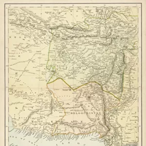
Map of the Heri-Rud Valley, from Pul-i-Khatun to Zulfagar, showing the Positions recently seized by Russia (engraving)
")
![]()
Wall Art and Photo Gifts from Fine Art Finder
Map of the Heri-Rud Valley, from Pul-i-Khatun to Zulfagar, showing the Positions recently seized by Russia (engraving)
1591008 Map of the Heri-Rud Valley, from Pul-i-Khatun to Zulfagar, showing the Positions recently seized by Russia (engraving) by English School, (19th century); Private Collection; (add.info.: Map of the Heri-Rud Valley, from Pul-i-Khatun to Zulfagar, showing the Positions recently seized by Russia. Illustration for The Illustrated London News, 14 March 1885.
English School (19th Century)); Look and Learn / Illustrated Papers Collection
Media ID 23070702
© Look and Learn / Illustrated Papers Collection / Bridgeman Images
Afghanistan Aide De Camp Borders Iran Positions Seized Showing Khatun
FEATURES IN THESE COLLECTIONS
> Asia
> Afghanistan
> Maps
> Asia
> Iran
> Related Images
> Europe
> Russia
> Related Images
> Fine Art Finder
> Artists
> English School
> Maps and Charts
> Related Images
EDITORS COMMENTS
This engraving titled "Map of the Heri-Rud Valley, from Pul-i-Khatun to Zulfagar, showing the Positions recently seized by Russia" takes us back to a significant moment in history. Created by an English School artist in the 19th century, this print offers a detailed illustration of the borders and positions that were recently captured by Russia. The map showcases the strategic locations within the Heri-Rud Valley, stretching from Pul-i-Khatun to Zulfagar. It highlights how these areas were seized by Russian forces during this period. The accuracy and intricacy of this map provide valuable insight into geopolitical events unfolding at that time. One cannot help but be drawn into studying every detail on this historical document. The presence of General Sir Peter Lumsden, British Afghan Boundary Commissioner and his aide-de-camp is depicted as they navigate through this complex region. As we explore this image further, it becomes apparent that it not only serves as a cartographic representation but also sheds light on political tensions between Afghanistan and Russia during that era. This artwork provides a glimpse into an important chapter in Central Asian history when various powers vied for control over territories. Preserved within a private collection today, this engraving originally appeared in The Illustrated London News on March 14th, 1885. Its significance lies not only in its artistic value but also as a testament to the ever-changing dynamics between nations throughout time.
MADE IN THE USA
Safe Shipping with 30 Day Money Back Guarantee
FREE PERSONALISATION*
We are proud to offer a range of customisation features including Personalised Captions, Color Filters and Picture Zoom Tools
SECURE PAYMENTS
We happily accept a wide range of payment options so you can pay for the things you need in the way that is most convenient for you
* Options may vary by product and licensing agreement. Zoomed Pictures can be adjusted in the Cart.