Home > Arts > Landscape paintings > Waterfall and river artworks > River artworks
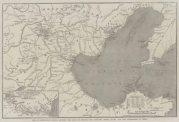
Map of North-East China, showing the Gulf of Pechili, the Tien-Tsin (Peiho) River, and the Approaches to Pekin (engraving)
![]()

Wall Art and Photo Gifts from Fine Art Finder
Map of North-East China, showing the Gulf of Pechili, the Tien-Tsin (Peiho) River, and the Approaches to Pekin (engraving)
1612285 Map of North-East China, showing the Gulf of Pechili, the Tien-Tsin (Peiho) River, and the Approaches to Pekin (engraving) by Dower, John (fl.c.1845-55); Private Collection; (add.info.: Map of North-East China, showing the Gulf of Pechili, the Tien-Tsin (Peiho) River, and the Approaches to Pekin. Illustration for The Illustrated London News, 21 July 1860.
John Dower); Look and Learn / Illustrated Papers Collection
Media ID 23411226
© Look and Learn / Illustrated Papers Collection / Bridgeman Images
Approaches Peiho River Pekin Showing Bohai Sea Chineses
FEATURES IN THESE COLLECTIONS
> Arts
> Landscape paintings
> Waterfall and river artworks
> River artworks
> Fine Art Finder
> Artists
> English School
> Fine Art Finder
> Artists
> John Dower
> Maps and Charts
> Related Images
EDITORS COMMENTS
This engraving, titled "Map of North-East China, showing the Gulf of Pechili, the Tien-Tsin (Peiho) River, and the Approaches to Pekin" takes us on a journey through time and space. Created by John Dower in the mid-19th century, this intricate map offers a glimpse into an era when exploration and discovery were at their peak. The detailed illustration showcases the vast region of North-East China with remarkable precision. The Gulf of Pechili dominates the foreground, its waters stretching out towards the horizon. The Tien-Tsin (Peiho) River winds its way through the landscape like a lifeline connecting different parts of this ancient land. As our eyes follow these waterways inland, we are led to one of China's most iconic cities – Pekin (now known as Beijing). The map highlights various approaches to this historic capital city, revealing trade routes and strategic paths that have shaped Chinese history for centuries. With every stroke meticulously engraved by Dower's skilled hand, this print is not only a testament to his artistic talent but also serves as an invaluable historical document. It allows us to explore China's past from afar and appreciate its rich cultural heritage. Whether you are an avid explorer or simply intrigued by cartography, this exquisite print will transport you back in time and immerse you in the beauty and complexity of North-East China.
MADE IN THE USA
Safe Shipping with 30 Day Money Back Guarantee
FREE PERSONALISATION*
We are proud to offer a range of customisation features including Personalised Captions, Color Filters and Picture Zoom Tools
SECURE PAYMENTS
We happily accept a wide range of payment options so you can pay for the things you need in the way that is most convenient for you
* Options may vary by product and licensing agreement. Zoomed Pictures can be adjusted in the Cart.


