Home > North America > United States of America > North Carolina > Wilmington
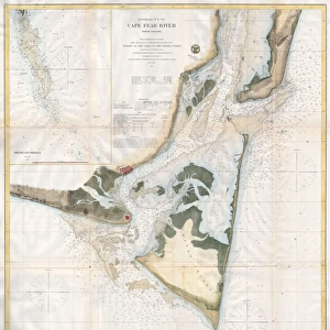
Wilmington and Cape Fear River, North Carolina (engraving)
")
![]()
Wall Art and Photo Gifts from Fine Art Finder
Wilmington and Cape Fear River, North Carolina (engraving)
1610146 Wilmington and Cape Fear River, North Carolina (engraving) by Dower, John (fl.c.1845-55); Private Collection; (add.info.: Wilmington and Cape Fear River, North Carolina. Illustration for The Illustrated London News, 18 February 1865.
John Dower); Look and Learn / Illustrated Papers Collection
Media ID 23003916
© Look and Learn / Illustrated Papers Collection / Bridgeman Images
American Civil War North Carolina Wilmington Cape Fear River
FEATURES IN THESE COLLECTIONS
> Fine Art Finder
> Artists
> English School
> Fine Art Finder
> Artists
> John Dower
> Maps and Charts
> Related Images
> North America
> United States of America
> North Carolina
> Wilmington
EDITORS COMMENTS
This engraving, titled "Wilmington and Cape Fear River, North Carolina" takes us back in time to the tumultuous era of the American Civil War. Created by John Dower, a talented artist from the mid-19th century, this print offers a glimpse into the historical significance of Wilmington and its connection to the Cape Fear River. The intricate details showcased in this artwork transport us to 1865 when it was featured in The Illustrated London News. As we explore this scene, we can almost hear the sounds of bustling activity along the riverbanks and imagine ships navigating through its waters. Dower's depiction captures both the beauty and strategic importance of Wilmington during that period. With its position as a major port city for Confederate forces, it played a crucial role in supplying goods and resources throughout the South. As we delve deeper into this image, our eyes are drawn to meticulously illustrated maps that adorn its borders. These maps serve as reminders of how geography shaped military strategies during one of America's most significant conflicts. Preserved within private collections today, this print serves as an invaluable piece of history. It allows us to reflect on not only Wilmington's past but also on how art can immortalize moments that have shaped nations.
MADE IN THE USA
Safe Shipping with 30 Day Money Back Guarantee
FREE PERSONALISATION*
We are proud to offer a range of customisation features including Personalised Captions, Color Filters and Picture Zoom Tools
SECURE PAYMENTS
We happily accept a wide range of payment options so you can pay for the things you need in the way that is most convenient for you
* Options may vary by product and licensing agreement. Zoomed Pictures can be adjusted in the Cart.