Home > Europe > France > Paris > Maps
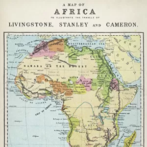
Map of Africa, published in 1700, Paris (colour engraving)
")
![]()
Wall Art and Photo Gifts from Fine Art Finder
Map of Africa, published in 1700, Paris (colour engraving)
REV345805 Map of Africa, published in 1700, Paris (colour engraving) by Delisle, Guillaume (1675-1726) (after); Private Collection; (add.info.: Guillaume de L Isle, geographe du Roi de France; geographer of King of France; ); French, out of copyright
Media ID 23377444
© Bridgeman Images
Continent Geographical Mapping
FEATURES IN THESE COLLECTIONS
> Africa
> Related Images
> Europe
> France
> Paris
> Maps
> Fine Art Finder
> Artists
> French School
> Fine Art Finder
> Artists
> Guillaume (after) Delisle
> Fine Art Finder
> Maps (celestial & Terrestrial)
> Maps and Charts
> Related Images
EDITORS COMMENTS
This print showcases a remarkable piece of cartographic history - the "Map of Africa, published in 1700, Paris". Created by the renowned French geographer Guillaume de L'Isle, who served as the official geographer to the King of France, this exquisite colour engraving offers a glimpse into the world of mapping during the early 18th century. The map presents an intricate and detailed representation of the African continent. From its northern shores bordering Europe to its southernmost tip, every corner is meticulously depicted with precision and artistry. The various regions are labeled with names that evoke both curiosity and historical significance - from "pays des cafres" to "nigritie" and "barbarie". As we explore this vintage masterpiece, it becomes evident that it not only serves as a geographical tool but also reflects European perceptions and knowledge about Africa at that time. It provides valuable insights into how Europeans viewed different parts of Africa in terms of their cultural diversity, natural resources, and political boundaries. With its rich colors and fine engravings, this print captures our imagination while transporting us back to an era when maps were highly sought-after treasures. It reminds us of the importance placed on exploration and understanding distant lands during a period marked by colonial expansion. Preserved within private collections today, this extraordinary artwork continues to inspire awe for its beauty as well as its historical significance.
MADE IN THE USA
Safe Shipping with 30 Day Money Back Guarantee
FREE PERSONALISATION*
We are proud to offer a range of customisation features including Personalised Captions, Color Filters and Picture Zoom Tools
SECURE PAYMENTS
We happily accept a wide range of payment options so you can pay for the things you need in the way that is most convenient for you
* Options may vary by product and licensing agreement. Zoomed Pictures can be adjusted in the Cart.