Home > Arts > Artists > H > Franz Hogenberg
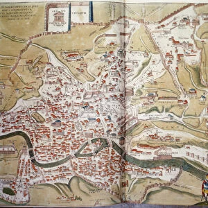
Map of Bruges (Brugae), Belgium (etching, 1572-1617)
, Belgium (etching, 1572-1617)")
![]()
Wall Art and Photo Gifts from Fine Art Finder
Map of Bruges (Brugae), Belgium (etching, 1572-1617)
LRI4707927 Map of Bruges (Brugae), Belgium (etching, 1572-1617) by Hogenberg, Franz (1540-c.1590); Private Collection; (add.info.: Plan de Bruges (Brugae), Belgium - Eau forte extracted from Civitates Orbis Terrarum (Atlas of the cities of the world) by Georg Braun (1541-1622) and Franz Hogenberg (1540-1590), published from 1572 to 1617 - Bruges, Belgium - From " Civitates Orbis Terrarum" by G. Braun and F. Hogenberg 2-1617); Luisa Ricciarini; Netherlandish, out of copyright
Media ID 22467744
© Luisa Ricciarini / Bridgeman Images
Atlas Book Canal Flemish Region Exterior View Geographical Map
FEATURES IN THESE COLLECTIONS
> Arts
> Artists
> H
> Franz Hogenberg
> Europe
> Belgium
> Related Images
> Fine Art Finder
> Artists
> Franz Hogenberg
> Fine Art Finder
> Artists
> French School
> Maps and Charts
> Related Images
> Maps and Charts
> World
EDITORS COMMENTS
This etching, titled "Map of Bruges (Brugae), Belgium" takes us back in time to the 16th century. Created by Franz Hogenberg, a renowned Netherlandish artist, this print is part of the esteemed atlas known as Civitates Orbis Terrarum. The map showcases the picturesque city of Bruges with intricate detail and precision. From its charming canals winding through the streets to its magnificent architecture, every aspect of this Flemish region is beautifully captured. The viewer is transported to a bygone era, where they can explore the city's layout and immerse themselves in its rich history. Published between 1572 and 1617, this map holds immense historical significance. It provides valuable insights into how Bruges looked during that period and serves as a testament to the skillful craftsmanship of Hogenberg. The collaboration between Georg Braun and Franz Hogenberg resulted in an extraordinary collection that documented cities from all over the world. Luisa Ricciarini has preserved this remarkable piece of art for future generations to admire. Through her dedication, we are able to appreciate not only the beauty but also the cultural heritage encapsulated within this etching. As we gaze upon it, we are reminded of Bruges' enduring allure and its place in European history.
MADE IN THE USA
Safe Shipping with 30 Day Money Back Guarantee
FREE PERSONALISATION*
We are proud to offer a range of customisation features including Personalised Captions, Color Filters and Picture Zoom Tools
SECURE PAYMENTS
We happily accept a wide range of payment options so you can pay for the things you need in the way that is most convenient for you
* Options may vary by product and licensing agreement. Zoomed Pictures can be adjusted in the Cart.