Home > Arts > Artists > A > Battista Agnese
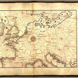
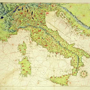
Navigation chart showing China, Ceylon and the Philippines and the Tropics of Cancer and Capricorn, c. 1540 (vellum)
")
![]()
Wall Art and Photo Gifts from Fine Art Finder
Navigation chart showing China, Ceylon and the Philippines and the Tropics of Cancer and Capricorn, c. 1540 (vellum)
3854274 Navigation chart showing China, Ceylon and the Philippines and the Tropics of Cancer and Capricorn, c.1540 (vellum) by Agnese, Battista (1514-64); Photo © Derek Bayes. All rights reserved 2022
Media ID 22292032
© Derek Bayes. All rights reserved 2022 / Bridgeman Images
Bengal Cartography Ceylon Chart Compass Filipino Nautical Navigation Pacific Ocean Philippines South East Asia Sri Lanka Sri Lankan Tropic Of Cancer Tropic Of Capricorn 16 16th Xvi Xvith Sixteenth Century Agnese Battista Chineses Portolan Chart
FEATURES IN THESE COLLECTIONS
> Arts
> Artists
> A
> Battista Agnese
> Arts
> Artists
> D
> Gustave Dore
> Asia
> Philippines
> Maps
> Fine Art Finder
> Artists
> Battista Agnese
> Fine Art Finder
> Artists
> Gustave Dore
> Maps and Charts
> Early Maps
EDITORS COMMENTS
This print showcases a remarkable navigation chart from the 16th century, created by the skilled cartographer Agnese Battista. Painted on vellum, this intricate map provides a glimpse into the maritime world of that era. The chart depicts China, Ceylon (now known as Sri Lanka), and the Philippines, along with the Tropics of Cancer and Capricorn. With its detailed representation of coastlines and waterways, this historical artifact served as an essential tool for sailors navigating through the vast Pacific Ocean. Its significance lies not only in its navigational purpose but also in its artistic beauty. The delicate brushstrokes and vibrant colors bring life to this ancient map. As we examine this piece closely, we can imagine naval explorers relying on it to traverse uncharted territories during their voyages. The presence of compasses indicates how crucial accurate navigation was for these brave seafarers. This portolan chart is a testament to Agnese Battista's mastery in capturing geographical information with precision and artistry. It stands as a valuable relic from a time when exploration shaped our understanding of distant lands. Derek Bayes' expert photography captures every detail of this magnificent work, allowing us to appreciate its historical significance today. Through his lens, we are transported back to an era where maps were not just tools but works of art that guided adventurers across treacherous seas.
MADE IN THE USA
Safe Shipping with 30 Day Money Back Guarantee
FREE PERSONALISATION*
We are proud to offer a range of customisation features including Personalised Captions, Color Filters and Picture Zoom Tools
SECURE PAYMENTS
We happily accept a wide range of payment options so you can pay for the things you need in the way that is most convenient for you
* Options may vary by product and licensing agreement. Zoomed Pictures can be adjusted in the Cart.