Home > Europe > France > Maps
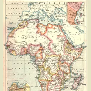
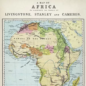
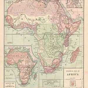
Map of Africa after the signing of the Anglo-French Agreement of March 1899 (colour litho)
")
![]()
Wall Art and Photo Gifts from Fine Art Finder
Map of Africa after the signing of the Anglo-French Agreement of March 1899 (colour litho)
2819021 Map of Africa after the signing of the Anglo-French Agreement of March 1899 (colour litho) by French School, (19th century); Private Collection; (add.info.: Map of Africa after the signing of the Anglo-French Agreement of March 1899. The agreement stipulated that French colonial expansion eastwards in Africa would stop at the watershed of the Nile. Carte de l Afrique d apres la convention Franco-Anglaise. Illustration for Le Petit Journal, 9 April 1899.); © Look and Learn
Media ID 22704932
© Look and Learn / Bridgeman Images
Agreement Boundary Colonies Diplomacy Division Foreign Relations Imperialism Scramble For Africa Britiain
FEATURES IN THESE COLLECTIONS
> Africa
> Related Images
> Europe
> United Kingdom
> Maps
> Fine Art Finder
> Artists
> French School
> Fine Art Finder
> Artists
> Henri (after) Meyer
> Maps and Charts
> British Empire Maps
> Maps and Charts
> Related Images
EDITORS COMMENTS
This vibrant and historically significant print showcases the "Map of Africa after the signing of the Anglo-French Agreement of March 1899". Created by the French School in the 19th century, this colour lithograph provides a visual representation of the diplomatic agreement between Britain and France during the era of colonial expansion. The map illustrates how this agreement dictated that French colonial expansion eastwards in Africa would cease at the watershed of the Nile. It captures a pivotal moment in history when European powers were engaged in what became known as "the scramble for Africa" vying for control over territories and resources on the continent. With its intricate details and vivid colours, this map offers valuable insights into politics, geography, and foreign relations during that time period. It highlights both British and French colonies, showcasing their spheres of influence across Africa. The division between these two European powers is evident, reflecting their respective imperial ambitions. Beyond its historical significance, this print also serves as a reminder of Europe's complex relationship with Africa. It sheds light on issues such as imperialism, colonialism, boundaries, and diplomacy that continue to shape our understanding of global politics today. Overall, this image invites viewers to explore not only African history but also broader themes related to empire building and international relations in the late 19th century.
MADE IN THE USA
Safe Shipping with 30 Day Money Back Guarantee
FREE PERSONALISATION*
We are proud to offer a range of customisation features including Personalised Captions, Color Filters and Picture Zoom Tools
SECURE PAYMENTS
We happily accept a wide range of payment options so you can pay for the things you need in the way that is most convenient for you
* Options may vary by product and licensing agreement. Zoomed Pictures can be adjusted in the Cart.