Home > Europe > United Kingdom > England > London > Museums > National Maritime Museum
Chart of New Zealand, 1856-81 (print)
")
![]()
Wall Art and Photo Gifts from Fine Art Finder
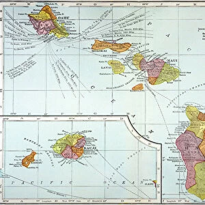
Chart of New Zealand, 1856-81 (print)
7342581 Chart of New Zealand, 1856-81 (print) by Walker, J. & C. (19th century); 67x98 cm; National Maritime Museum, London, UK; (add.info.: Creator: HM Admiralty; J & C Walker; Vice-Admiral Byron Drury
Pacific Ocean NEW ZEALAND From Surveys in HM Ships Acheron & Pandora Captn JL Stokes, Comndrs B Drury & GH Richards Assisted by... 1848-1855); © National Maritime Museum, Greenwich, London
Media ID 38341314
© © National Maritime Museum, Greenwich, London / Bridgeman Images
Dominion Of New Zealand New Zealand New Zealander New Zealanders Polynesia Polynesians Polynesisch
FEATURES IN THESE COLLECTIONS
> Arts
> Artists
> P
> Polynesian Polynesian
> Europe
> United Kingdom
> England
> London
> Boroughs
> Greenwich
> Europe
> United Kingdom
> England
> London
> Museums
> Greenwich Heritage Centre
> Europe
> United Kingdom
> England
> London
> Museums
> National Maritime Museum
> Europe
> United Kingdom
> England
> London
> Towns
> Greenwich
> Europe
> United Kingdom
> Heritage Sites
> Maritime Greenwich
> Europe
> United Kingdom
> Maps
> Fine Art Finder
> Artists
> J. & C. Walker
> Maps and Charts
> Early Maps
> Oceania
> New Zealand
> Maps
> Oceania
> New Zealand
> Related Images
EDITORS COMMENTS
This stunning print of the Chart of New Zealand, created between 1856-81 by HM Admiralty and J & C Walker, offers a fascinating glimpse into the exploration and mapping of this beautiful Pacific Ocean nation. The detailed chart, measuring 67x98 cm, was based on surveys conducted in HM Ships Acheron & Pandora under the command of Captains JL Stokes, B Drury, and GH Richards from 1848-1855.
The intricate lines and markings on this map reflect the dedication and precision required for early cartography in the nineteenth century. It serves as a testament to the adventurous spirit of explorers who ventured into uncharted waters to uncover new lands and expand our understanding of the world.
As you study this black-and-white representation of New Zealand's coastlines and topography, you can't help but be transported back in time to an era when discovery was at its peak. The Dominion of New Zealand comes alive through this historical document, showcasing not only its geographical features but also its rich cultural heritage.
Whether you're a history buff or simply appreciate fine artistry, this print is sure to captivate your imagination with its blend of scientific accuracy and artistic flair. Display it proudly in your home or office as a conversation piece that celebrates both the beauty and complexity of one of Oceania's most enchanting destinations.
MADE IN THE USA
Safe Shipping with 30 Day Money Back Guarantee
FREE PERSONALISATION*
We are proud to offer a range of customisation features including Personalised Captions, Color Filters and Picture Zoom Tools
SECURE PAYMENTS
We happily accept a wide range of payment options so you can pay for the things you need in the way that is most convenient for you
* Options may vary by product and licensing agreement. Zoomed Pictures can be adjusted in the Cart.