Home > Europe > United Kingdom > England > London > Museums > National Maritime Museum
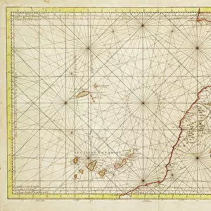
Chart of Gibraltar, 1761 (engraving)
")
![]()
Wall Art and Photo Gifts from Fine Art Finder
Chart of Gibraltar, 1761 (engraving)
7339358 Chart of Gibraltar, 1761 (engraving) by Bellin, Jacques Nicolas (1703-72) ; 61x91 cm; National Maritime Museum, London, UK; (add.info.: Creator: Jacques Nicolas Bellin
Single sheet. Engr. Scale: [ca. 1:200 000 (bar)]. Cartographic Note: North at 270 degrees. Borders graduated for lat & long. Rhumb lines. Variation shown. Soundings. Tidal flow in the Strait indicated. Contents Note: Inset: Plan de Gibraltar [ca. 1:19 000 (bar)], Tide tables for the coast of Europe and the coast of Africa. Inscribed Carte du detroit de Gibraltar'.); © National Maritime Museum, Greenwich, London
Media ID 38176988
© © National Maritime Museum, Greenwich, London / Bridgeman Images
FEATURES IN THESE COLLECTIONS
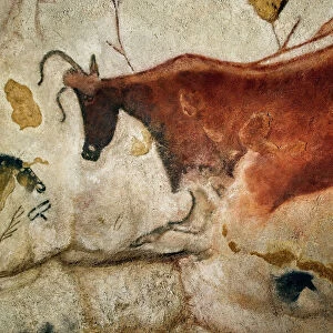
> Animals
> Insects
> Hemiptera
> Black Scale
> Europe
> Spain
> Related Images
> Europe
> United Kingdom
> England
> London
> Boroughs
> Greenwich
> Europe
> United Kingdom
> England
> London
> Museums
> Greenwich Heritage Centre
> Europe
> United Kingdom
> England
> London
> Museums
> National Maritime Museum
> Europe
> United Kingdom
> England
> London
> Towns
> Greenwich
> Europe
> United Kingdom
> Heritage Sites
> Maritime Greenwich
> Europe
> United Kingdom
> Maps
> Fine Art Finder
> Artists
> Hermann Moll
> Fine Art Finder
> Artists
> Jacques Nicolas Bellin
EDITORS COMMENTS
This stunning engraving from 1761 depicts a detailed Chart of Gibraltar, showcasing the strategic importance of this iconic location. Created by Jacques Nicolas Bellin, a renowned cartographer of the 18th century, this engraving measures 61x91 cm and is housed in the National Maritime Museum in London.
The intricate details on the map include rhumb lines, soundings, tidal flow indications in the Strait, and even variations in geography. The borders are graduated for latitude and longitude, with a north orientation at 270 degrees. An inset plan of Gibraltar is also included, providing a closer look at this historic site.
As one examines this historical artifact, they can't help but be transported back to a time when cartography was both an art form and a science. The precision and craftsmanship involved in creating such maps are truly remarkable.
This Chart of Gibraltar serves as not only a navigational tool but also as a piece of art that captures the essence of European exploration during the 18th century. It stands as a testament to human curiosity and ingenuity in mapping out our world's wonders.
MADE IN THE USA
Safe Shipping with 30 Day Money Back Guarantee
FREE PERSONALISATION*
We are proud to offer a range of customisation features including Personalised Captions, Color Filters and Picture Zoom Tools
SECURE PAYMENTS
We happily accept a wide range of payment options so you can pay for the things you need in the way that is most convenient for you
* Options may vary by product and licensing agreement. Zoomed Pictures can be adjusted in the Cart.