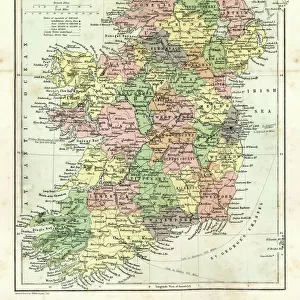
Home > Europe > United Kingdom > Northern Ireland > Maps
Map of Scotland showing Telford's and military roads, 1850

![]()
Wall Art and Photo Gifts from Fine Art Finder
Map of Scotland showing Telford's and military roads, 1850
3359154 Map of Scotland showing Telford's and military roads, 1850; (add.info.: Map of Scotland showing Telford's roads (dotted lines) and military roads (solid lines). Thomas Telford (1757-1834) a Scottish engineer, architect, and stonemason. Dated 19th Century.); Universal History Archive/UIG
Media ID 38257988
© Universal History Archive/UIG / Bridgeman Images
Engineer Line Lines Roads Stonemason Thomas Telford Architects Scotland Scotish Telford
FEATURES IN THESE COLLECTIONS
> Europe
> Republic of Ireland
> Maps
> Europe
> United Kingdom
> Maps
> Europe
> United Kingdom
> Northern Ireland
> Maps
> Europe
> United Kingdom
> Northern Ireland
> Posters
> Europe
> United Kingdom
> Northern Ireland
> Related Images
> Europe
> United Kingdom
> Scotland
> Maps
> Fine Art Finder
> Artists
> Italian School
> Maps and Charts
> Early Maps
> Maps and Charts
> Related Images
EDITORS COMMENTS
This print of a Map of Scotland from 1850 showcases the intricate network of Telford's and military roads across the country. The dotted lines represent Thomas Telford's innovative roadways, highlighting his engineering prowess and dedication to improving transportation infrastructure in Scotland.
Thomas Telford, a Scottish engineer, architect, and stonemason, left behind a lasting legacy with his contributions to road construction during the 19th century. His solid lines on this map symbolize the military roads that were strategically built for efficient travel and communication throughout Scotland.
As you study this historical map, you can't help but appreciate the meticulous detail put into plotting out each route and connecting various regions together. The blend of artistry and functionality in cartography is truly remarkable in this piece.
From Edinburgh to Inverness, Glasgow to Aberdeen, every corner of Scotland is intricately mapped out on this piece of history. It serves as a reminder of how far transportation technology has come since the days when these roads were first laid down by skilled hands.
This print is not just a visual representation of geographical locations; it tells a story of progress, innovation, and connectivity that continues to shape our world today.
MADE IN THE USA
Safe Shipping with 30 Day Money Back Guarantee
FREE PERSONALISATION*
We are proud to offer a range of customisation features including Personalised Captions, Color Filters and Picture Zoom Tools
SECURE PAYMENTS
We happily accept a wide range of payment options so you can pay for the things you need in the way that is most convenient for you
* Options may vary by product and licensing agreement. Zoomed Pictures can be adjusted in the Cart.