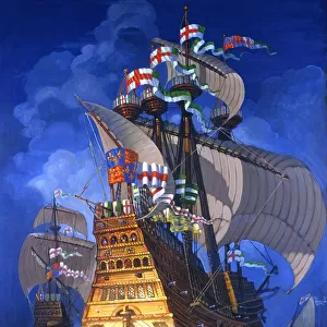
Home > Europe > United Kingdom > England > London > Sport > Sailing
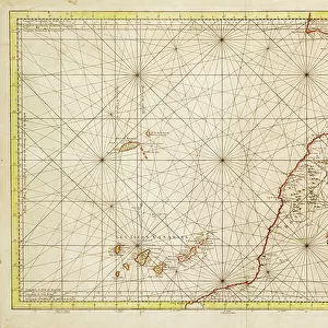
Hydrographic chart of the Bay of Cadiz, 1762 (engraving)
")
![]()
Wall Art and Photo Gifts from Fine Art Finder
Hydrographic chart of the Bay of Cadiz, 1762 (engraving)
7339383 Hydrographic chart of the Bay of Cadiz, 1762 (engraving) by Bellin, Jacques Nicolas (1703-72) ; 61x93 cm; National Maritime Museum, London, UK; (add.info.: Creator: Jacques Nicolas Bellin
Single sheet. Engr. Medium: Linen backed. Scale: [ca. 1:23 000 (bar)]. Cartographic Note: North at 297 degrees. Ungraduated. Rhumbs. Variation shown. Rocks & soundings. Scale in toise & leagues. Additional Places: Cadiz. Contents Note: Text panel of sailing directions for entering Cadiz.Inscribed Carte hydrographique de la baye de Cadix dressee au Depost des Cartes et Plans de la Marine...par le S. Bellin Ingenieur de la Marine...1762.'); © National Maritime Museum, Greenwich, London
Media ID 38176938
© © National Maritime Museum, Greenwich, London / Bridgeman Images
Andalucia Andalusia Andalusian Cadiz
FEATURES IN THESE COLLECTIONS
> Animals
> Insects
> Hemiptera
> Black Scale
> Europe
> United Kingdom
> England
> London
> Boroughs
> Greenwich
> Europe
> United Kingdom
> England
> London
> Museums
> Greenwich Heritage Centre
> Europe
> United Kingdom
> England
> London
> Museums
> National Maritime Museum
> Europe
> United Kingdom
> England
> London
> Sport
> Sailing
> Europe
> United Kingdom
> England
> London
> Towns
> Greenwich
> Europe
> United Kingdom
> Heritage Sites
> Maritime Greenwich
> Europe
> United Kingdom
> Maps
> Fine Art Finder
> Artists
> Jacques Nicolas Bellin
> Maps and Charts
> Early Maps
EDITORS COMMENTS
This stunning engraving of the Hydrographic chart of the Bay of Cadiz, dating back to 1762, offers a fascinating glimpse into the maritime history of Spain. Created by Jacques Nicolas Bellin, a renowned marine engineer of the time, this intricate map showcases detailed information about the bay and its surroundings.
Measuring 61x93 cm and displayed at the National Maritime Museum in London, UK, this piece is not just a work of art but also a valuable historical document. The map features north at 297 degrees with ungraduated rhumbs and variations shown. It includes rocks and soundings as well as scales in toise and leagues for navigation purposes.
The inscription on the map reads 'Carte hydrographique de la baye de Cadix dressee au Depost des Cartes et Plans de la Marine...par le S. Bellin Ingenieur de la Marine...1762,' adding an authentic touch to its historical significance.
With its black-and-white aesthetic and meticulous attention to detail, this engraving transports viewers back to the early 18th century when cartography was both an art form and a science. A true masterpiece that captures the essence of Spanish maritime heritage, this print is sure to be a conversation starter in any space it graces.
MADE IN THE USA
Safe Shipping with 30 Day Money Back Guarantee
FREE PERSONALISATION*
We are proud to offer a range of customisation features including Personalised Captions, Color Filters and Picture Zoom Tools
SECURE PAYMENTS
We happily accept a wide range of payment options so you can pay for the things you need in the way that is most convenient for you
* Options may vary by product and licensing agreement. Zoomed Pictures can be adjusted in the Cart.