Home > Europe > Estonia > Maps
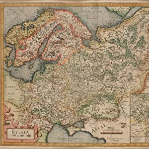
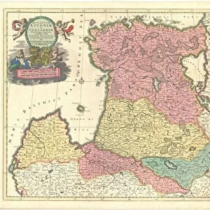
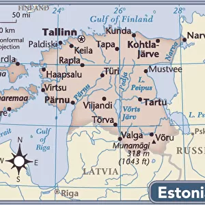
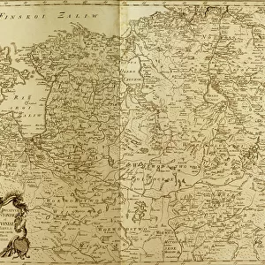
Map of Estonia and Livonia - Anonymous master - 1745 - Copper engraving, watercolour - Academy of Sciences, Saint Petersburg

![]()
Wall Art and Photo Gifts from Fine Art Finder
Map of Estonia and Livonia - Anonymous master - 1745 - Copper engraving, watercolour - Academy of Sciences, Saint Petersburg
FIA5397704 Map of Estonia and Livonia - Anonymous master - 1745 - Copper engraving, watercolour - Academy of Sciences, Saint Petersburg by Unknown artist, (18th century); Russian Academy of Sciences Library Depository St Petersburg; Photo © Fine Art Images
Media ID 24676986
© Fine Art Images / Bridgeman Images
FEATURES IN THESE COLLECTIONS
> Europe
> Estonia
> Related Images
> Europe
> Russia
> Related Images
> Europe
> Russia
> Saint Petersburg
> Fine Art Finder
> Artists
> Jean Jacques Bachelier
> Fine Art Finder
> Artists
> Unknown Artist
> Maps and Charts
> Related Images
EDITORS COMMENTS
This print showcases a remarkable piece of cartographic art, the "Map of Estonia and Livonia". Created by an anonymous master in 1745, this copper engraving with delicate watercolor accents is housed in the prestigious Academy of Sciences in Saint Petersburg. The Fine Art Images' photograph beautifully captures the intricate details and vibrant colors that bring this historical map to life. The map itself provides a fascinating glimpse into the geographical landscape of Estonia and Livonia during the 18th century. Its meticulous craftsmanship allows viewers to explore these Baltic regions through its precise markings and labels. This valuable resource would have been invaluable for navigators, scholars, and explorers seeking knowledge about these territories. The use of color adds depth and richness to this artistic creation. Each hue carefully chosen to enhance specific features on the map, making it visually engaging while also serving as a practical tool for understanding various geographic elements. As we admire this masterpiece from centuries past, we are reminded of how art can transcend time and serve as both an aesthetic pleasure and an educational resource. Thanks to Bridgeman Images' collaboration with Fine Art Finder, we can now appreciate this extraordinary artwork from wherever we may be situated in the world.
MADE IN THE USA
Safe Shipping with 30 Day Money Back Guarantee
FREE PERSONALISATION*
We are proud to offer a range of customisation features including Personalised Captions, Color Filters and Picture Zoom Tools
SECURE PAYMENTS
We happily accept a wide range of payment options so you can pay for the things you need in the way that is most convenient for you
* Options may vary by product and licensing agreement. Zoomed Pictures can be adjusted in the Cart.