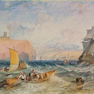
Home > Europe > United Kingdom > England > London > Museums > National Maritime Museum
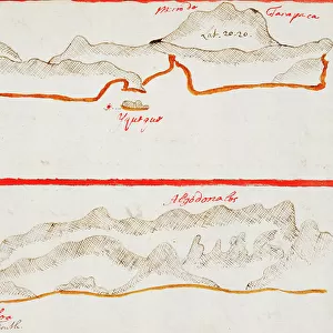
Rio Guayas, 1682 (coloured manuscript)
")
![]()
Wall Art and Photo Gifts from Fine Art Finder
Rio Guayas, 1682 (coloured manuscript)
7339608 Rio Guayas, 1682 (coloured manuscript) by Ringrose, Basil (c.1653-83); 16x20 cm; National Maritime Museum, London, UK; (add.info.: Creator: Basil Ringrose
Bound sheet. Col. ms. Additional Places: Ecuador. Contents Note: Soundings and anchorages shown. Latitude noted.
From a book of sailing directions of 110ff: 'The South Sea Waggoner shewing the making & bearing of all the coasts from California to the Streights of Le Maire done from the Spanish originall by Basil Ringrose'.
The charts all have a square pencil grid for making copies.); © National Maritime Museum, Greenwich, London
Media ID 38177040
© © National Maritime Museum, Greenwich, London / Bridgeman Images
Boat Dock Coast Line Colony Ecuador Equatorian Equatorians Geographer Harbor Area Harbour Area Harbours Latin America Port Area Seas Seawater
FEATURES IN THESE COLLECTIONS
> Animals
> Mammals
> Cricetidae
> California Mouse
> Arts
> Realistic drawings
> Pencil drawings
> Fine art
> Europe
> United Kingdom
> England
> London
> Boroughs
> Greenwich
> Europe
> United Kingdom
> England
> London
> Museums
> Greenwich Heritage Centre
> Europe
> United Kingdom
> England
> London
> Museums
> National Maritime Museum
> Europe
> United Kingdom
> England
> London
> Sport
> Sailing
> Europe
> United Kingdom
> England
> London
> Towns
> Greenwich
> Europe
> United Kingdom
> Heritage Sites
> Maritime Greenwich
> Europe
> United Kingdom
> Maps
> Fine Art Finder
> Artists
> Basil Ringrose
> Fine Art Finder
> Artists
> Joan Martines
EDITORS COMMENTS
This stunning coloured manuscript print of Rio Guayas from 1682 by Basil Ringrose offers a captivating glimpse into the maritime history of Ecuador. The intricate details and vibrant hues bring to life the coastlines, anchorages, and soundings along the South Sea Waggoner route from California to the Straits of Le Maire.
As you study this piece, you can almost feel the sense of adventure and exploration that must have filled sailors as they navigated these waters centuries ago. The pencil grid on each chart hints at the meticulous planning and precision required for successful voyages in those times.
The artistry and skill displayed in this map are truly remarkable, showcasing not only geographical accuracy but also an artistic flair that elevates it beyond a mere navigational tool. It is a testament to both Ringrose's talent as a cartographer and his dedication to documenting the world around him.
Whether you are a history buff, an art enthusiast, or simply someone who appreciates beautiful craftsmanship, this print is sure to captivate your imagination and transport you back in time to an era of seafaring exploration like no other.
MADE IN THE USA
Safe Shipping with 30 Day Money Back Guarantee
FREE PERSONALISATION*
We are proud to offer a range of customisation features including Personalised Captions, Color Filters and Picture Zoom Tools
SECURE PAYMENTS
We happily accept a wide range of payment options so you can pay for the things you need in the way that is most convenient for you
* Options may vary by product and licensing agreement. Zoomed Pictures can be adjusted in the Cart.