Home > Arts > Artists > R > Roman Roman
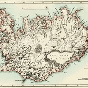
Ordnance survey map of Roman Britain (colour litho)
")
![]()
Wall Art and Photo Gifts from Fine Art Finder
Ordnance survey map of Roman Britain (colour litho)
3643686 Ordnance survey map of Roman Britain (colour litho) by English School, (20th century); Private Collection; (add.info.: Ordnance survey map of Roman Britain, second edition (c 1931). Beautifully printed, with a lot of detail.); © Look and Learn
Media ID 23637976
© Look and Learn / Bridgeman Images
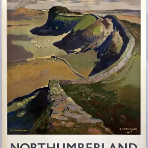
Britannia Cities Colonisation Hadrians Wall Roads Romans Settlements Northernmost
FEATURES IN THESE COLLECTIONS
> Arts
> Artists
> R
> Roman Roman
> Europe
> Italy
> Lazio
> Rome
> Europe
> United Kingdom
> England
> Maps
> Europe
> United Kingdom
> Heritage Sites
> Frontiers of the Roman Empire
> Europe
> United Kingdom
> Maps
> Europe
> United Kingdom
> Related Images
> Europe
> United Kingdom
> Scotland
> Maps
> Europe
> United Kingdom
> Scotland
> Posters
> Fine Art Finder
> Artists
> English School
> Fine Art Finder
> Artists
> John Cameron
EDITORS COMMENTS
This print showcases an exquisite Ordnance survey map of Roman Britain, a true treasure from the 20th century. The second edition of this map, created around 1931, is beautifully printed and brimming with intricate details that transport us back to ancient times. With settlements, cities, roads, and even Hadrian's Wall depicted on this map, it offers a fascinating glimpse into the vast extent of the Roman Empire's influence in Britannia. The map highlights significant locations such as Londinium (now London), Wales, Scotland, and various towns across England. It serves as a testament to the Romans' colonisation efforts and their lasting impact on British history. As we explore this visual representation of Roman Britain's landscape and infrastructure, we can't help but marvel at the meticulous craftsmanship that went into its creation. Notably featured are references to Germany and its connection to both Northern Germany and Germanic culture. This inclusion hints at the far-reaching influence of Rome beyond its borders in Europe during ancient times. Adorned with vibrant colors through lithography techniques, this Ordnance survey map invites us to delve deeper into British heritage while appreciating the rich tapestry woven by different cultures throughout history. Whether you're a history enthusiast or simply captivated by cartographic artistry, this print is sure to ignite your imagination as you embark on a journey through time across Great Britain's past civilizations.
MADE IN THE USA
Safe Shipping with 30 Day Money Back Guarantee
FREE PERSONALISATION*
We are proud to offer a range of customisation features including Personalised Captions, Color Filters and Picture Zoom Tools
SECURE PAYMENTS
We happily accept a wide range of payment options so you can pay for the things you need in the way that is most convenient for you
* Options may vary by product and licensing agreement. Zoomed Pictures can be adjusted in the Cart.