Home > Europe > Sweden > Maps
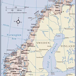
Map of Norway and Sweden (litho)
")
![]()
Wall Art and Photo Gifts from Fine Art Finder
Map of Norway and Sweden (litho)
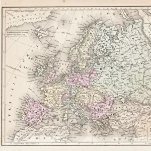
8661106 Map of Norway and Sweden (litho) by English School, (20th century); Private Collection; (add.info.: Map of Norway and Sweden. Norway is separated from Sweden by a natural barrier of mountains, the Kjolen range, which forms the backbone of the Scandinavian Peninsula. Constitutionally the two countries have been united and divided many times, but Norway declared its independence once more in 1905. Gotland, a Swedish island in the Baltic Sea, was once of great importance owing to its connection with the Hanseatic League. Illustration for Hutchinson's History of the Nations (Hutchinson, c.1920).); © Look and Learn
Media ID 38297036
© © Look and Learn / Bridgeman Images
Independence Independence Movement Mountain Scenery Moutains Norway Norway Norwegian Norwegian Norwegians Sverige Sweden Swedish
FEATURES IN THESE COLLECTIONS
> Europe
> Norway
> Related Images
> Europe
> Sweden
> Related Images
> Fine Art Finder
> Artists
> English School
> Fine Art Finder
> Artists
> John Harris Valda
> Maps and Charts
> Early Maps
EDITORS COMMENTS
This stunning lithograph print of a Map of Norway and Sweden captures the intricate details of these two Scandinavian countries. The map showcases the natural barrier of mountains, known as the Kjolen range, that separates Norway from Sweden. It also highlights Gotland, an important Swedish island in the Baltic Sea with ties to the Hanseatic League.
The historical significance of this map is evident, as it reflects the constitutional unity and division between Norway and Sweden over time. In 1905, Norway declared its independence once again, marking a pivotal moment in their shared history.
The black and white aesthetic adds a timeless quality to this piece, emphasizing the rich heritage and cultural heritage of both nations. The mountain scenery depicted on the map serves as a reminder of the rugged beauty that characterizes Scandinavia.
Overall, this Map of Norway and Sweden lithograph is not just a geographical representation but also a symbol of resilience, independence movements, and historical connections between these two European countries. It is a fascinating glimpse into their past and present identities.
MADE IN THE USA
Safe Shipping with 30 Day Money Back Guarantee
FREE PERSONALISATION*
We are proud to offer a range of customisation features including Personalised Captions, Color Filters and Picture Zoom Tools
SECURE PAYMENTS
We happily accept a wide range of payment options so you can pay for the things you need in the way that is most convenient for you
* Options may vary by product and licensing agreement. Zoomed Pictures can be adjusted in the Cart.