Home > Arts > Artists > S > John Seller
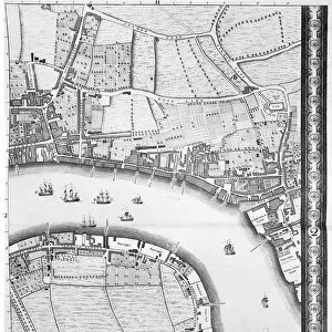
A chart of the sea coasts of England, Flanders and Holland, c.1672 (print)
")
![]()
Wall Art and Photo Gifts from Fine Art Finder
A chart of the sea coasts of England, Flanders and Holland, c.1672 (print)
7340614 A chart of the sea coasts of England, Flanders and Holland, c.1672 (print) by Seller, John (1632-97); National Maritime Museum, London, UK; (add.info.: Creator: John Seller
From Atlas maritimus : or a book of charts describeing... most of the knowne parts of the world); © National Maritime Museum, Greenwich, London
Media ID 38412580
© © National Maritime Museum, Greenwich, London / Bridgeman Images
Coast Line Flanders Belgians Belgium Belgian Dutch Netherlands Hollander Hollanders Netherland Netherlands Holland Dutch The Netherland
FEATURES IN THESE COLLECTIONS
> Arts
> Artists
> S
> John Seller
> Europe
> Belgium
> Related Images
> Europe
> Netherlands
> Maps
> Europe
> Netherlands
> Posters
> Europe
> Netherlands
> Related Images
> Europe
> Republic of Ireland
> Maps
> Europe
> United Kingdom
> England
> London
> Boroughs
> Greenwich
> Europe
> United Kingdom
> England
> London
> Museums
> British Museum
> Fine Art Finder
> Artists
> John Rocque
> Fine Art Finder
> Artists
> John Seller
EDITORS COMMENTS
This stunning print depicts a chart of the sea coasts of England, Flanders, and Holland from around 1672. Created by John Seller as part of his 'Atlas maritimus', this intricate map showcases the detailed coastlines and maritime features of these European regions during the 17th century.
The vibrant colors used in this print bring to life the coastal landscapes and seascapes, highlighting the importance of cartography in understanding navigation and trade routes during this period. The careful attention to detail in mapping out each coastline reflects Seller's dedication to accuracy and precision in his work.
As you gaze upon this historical artifact, you can almost feel yourself transported back in time to an era when exploration and discovery were at the forefront of human endeavor. The combination of artistry and scientific knowledge displayed in this print is truly awe-inspiring, reminding us of the rich history that lies behind every map ever created.
Whether you are a lover of history, geography, or simply appreciate fine craftsmanship, this print is sure to captivate your imagination and inspire a sense of wonder at the vastness and beauty of our world's coastlines.
MADE IN THE USA
Safe Shipping with 30 Day Money Back Guarantee
FREE PERSONALISATION*
We are proud to offer a range of customisation features including Personalised Captions, Color Filters and Picture Zoom Tools
SECURE PAYMENTS
We happily accept a wide range of payment options so you can pay for the things you need in the way that is most convenient for you
* Options may vary by product and licensing agreement. Zoomed Pictures can be adjusted in the Cart.