Home > Arts > Artists > W > Frederick de Wit
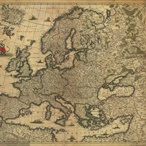
Pascaart van de Noort Zee verthoonende in zich alle de Custen en havens daer rontom gelegen. 1654 (print, paper)
")
![]()
Wall Art and Photo Gifts from Fine Art Finder
Pascaart van de Noort Zee verthoonende in zich alle de Custen en havens daer rontom gelegen. 1654 (print, paper)
7340057 Pascaart van de Noort Zee verthoonende in zich alle de Custen en havens daer rontom gelegen. 1654 (print, paper) by Wit, Frederick de (1630-1706); 50.5x58.5 cm; National Maritime Museum, London, UK; (add.info.: Creator: Frederik de Wit
Bound sheet. Hand col. engr. Scale: [ca. 1: (bar)]. Cartographic Note: North at 90 degrees. Graduated for latitude only. Bar scales in Dutch miles, Spanish miles and English and French miles. Additional Places: North Sea. Contents Note: Cartouche decoration includes navigational instruments - cross staff and sphere.
In an atlas of twelve charts, seven by Frederik de Wit and five by Theunis Jacobz.); © National Maritime Museum, Greenwich, London
Media ID 38412530
© © National Maritime Museum, Greenwich, London / Bridgeman Images
North Sea Norway Norway Norwegian Norwegian Norwegians Dutch Netherlands Hollander Hollanders Netherland Netherlands Holland Dutch Scotland Scotish The Netherland
FEATURES IN THESE COLLECTIONS
> Arts
> Artists
> W
> Frederick de Wit
> Europe
> Netherlands
> Maps
> Europe
> Netherlands
> Posters
> Europe
> Netherlands
> Related Images
> Europe
> Norway
> Related Images
> Europe
> Republic of Ireland
> Maps
> Fine Art Finder
> Artists
> Frederick de Wit
> Fine Art Finder
> Artists
> John Seller
EDITORS COMMENTS
This stunning print, "Pascaart van de Noort Zee verthoonende in zich alle de Custen en havens daer rontom gelegen" by Frederick de Wit, is a true masterpiece of 17th-century cartography. The intricate details and vibrant colors bring to life the coastlines and harbors surrounding the North Sea, providing a glimpse into the maritime world of centuries past.
Measuring at 50.5x58.5 cm, this print is part of an atlas containing twelve charts, seven by De Wit himself and five by Theunis Jacobz. The meticulous craftsmanship is evident in every aspect of this piece, from the carefully drawn navigational instruments in the cartouche decoration to the precise bar scales indicating Dutch miles, Spanish miles, English miles, and French miles.
The map's orientation with north at 90 degrees allows viewers to easily navigate through the various regions depicted on it. From Scotland to Norway to the Netherlands, each area is beautifully rendered with attention to detail that showcases De Wit's skill as a cartographer.
As you gaze upon this print from the National Maritime Museum in London, you can't help but be transported back in time to an era when exploration and discovery were paramount. It serves as a reminder of our rich maritime history and the importance of maps in shaping our understanding of the world around us.
MADE IN THE USA
Safe Shipping with 30 Day Money Back Guarantee
FREE PERSONALISATION*
We are proud to offer a range of customisation features including Personalised Captions, Color Filters and Picture Zoom Tools
SECURE PAYMENTS
We happily accept a wide range of payment options so you can pay for the things you need in the way that is most convenient for you
* Options may vary by product and licensing agreement. Zoomed Pictures can be adjusted in the Cart.