Home > Arts > Artists > H > Joris Hoefnagel
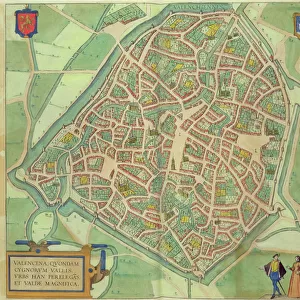
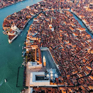
Map of Naples, from Civitates Orbis Terrarum by Georg Braun (1541-1622

![]()
Wall Art and Photo Gifts from Fine Art Finder
Map of Naples, from Civitates Orbis Terrarum by Georg Braun (1541-1622
STC121067 Map of Naples, from Civitates Orbis Terrarum by Georg Braun (1541-1622) and Frans Hogenberg (1535-90), c.1572 (coloured engraving) by Hoefnagel, Joris (1542-1600) (after); Private Collection; The Stapleton Collection; Flemish, out of copyright
Media ID 23370404
© The Stapleton Collection / Bridgeman Images
Aerial View Campania Cities Of The World Neapolitan Neapolis
FEATURES IN THESE COLLECTIONS
> Aerial Photography
> Related Images
> Arts
> Artists
> H
> Joris Hoefnagel
> Europe
> Italy
> Aerial Views
> Europe
> Italy
> Campania
> Naples
> Europe
> Italy
> Campania
> Related Images
> Fine Art Finder
> Artists
> Joris (after) Hoefnagel
> Fine Art Finder
> Maps (celestial & Terrestrial)
> Maps and Charts
> Italy
> Maps and Charts
> Related Images
EDITORS COMMENTS
This print showcases a remarkable piece of cartographic history - the "Map of Naples" from the renowned Civitates Orbis Terrarum by Georg Braun and Frans Hogenberg. Created in 1572, this coloured engraving offers an aerial view of the vibrant city nestled along the picturesque bay in Italy's Campania region. The intricate details captured in this map transport viewers back to a time when Naples was known as Neapolis, showcasing its rich historical significance. From its bustling harbor to the winding streets that weave through the city, every element is meticulously depicted by Joris Hoefnagel, who reproduced Braun and Hogenberg's original work. As one gazes upon this stunning print, they are transported into a world where ancient architecture coexists harmoniously with natural beauty. The enchanting blend of sea and land creates an awe-inspiring panorama that captures both locals and visitors alike. This masterpiece serves as a testament to the skillful artistry employed by these talented Flemish artists. Their attention to detail brings life to each building, street, and ship portrayed on this map. It not only serves as a navigational tool but also provides glimpses into daily life during that era. With its historical significance and artistic brilliance, this print is truly a treasure for any admirer of fine art or lover of geography. Its presence adds depth and character to any space it graces while reminding us of our connection to past civilizations.
MADE IN THE USA
Safe Shipping with 30 Day Money Back Guarantee
FREE PERSONALISATION*
We are proud to offer a range of customisation features including Personalised Captions, Color Filters and Picture Zoom Tools
SECURE PAYMENTS
We happily accept a wide range of payment options so you can pay for the things you need in the way that is most convenient for you
* Options may vary by product and licensing agreement. Zoomed Pictures can be adjusted in the Cart.