Home > Europe > United Kingdom > England > London > Museums > National Maritime Museum
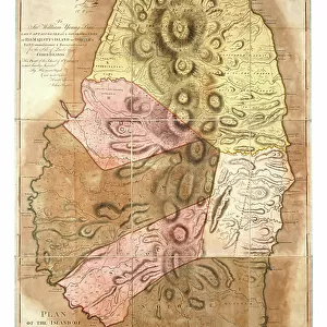
Plan of the Island of St Vincent laid down by actual survey, 1776 (paper)
")
![]()
Wall Art and Photo Gifts from Fine Art Finder
Plan of the Island of St Vincent laid down by actual survey, 1776 (paper)
7340448 Plan of the Island of St Vincent laid down by actual survey, 1776 (paper) by Bayly, John (fl.c.1754-1806); National Maritime Museum, London, UK; (add.info.: Creator: John Byres; J. Bayly;
Plan made under the direction of the Honorable Commissioners for the Sale of Lands in the Ceded Islands by John Byres Chief Surveyor 1776. Two sheets. Hand coloured engraving, segmented and backed. Scale: 1:33000 (bar). Cartographic note: Graduated map, meridians of London and Ferro. Scale in British statute miles and chains. Additional places - Caribbean, Lesser Antilles. Contents note: The area coloured yellow in the north is land granted to the Charibs by the late Treaty in 1773'. The plantations taken over from the French followed natural boundaries and so differ from the rectangular plots imposed on other ceded islands. The map is dedicated to Sir William Young, late Governor of Dominica.); © National Maritime Museum, Greenwich, London
Media ID 38177596
© © National Maritime Museum, Greenwich, London / Bridgeman Images
Caribbean Isles 18e Siecle 18th Century 18th Centuries
FEATURES IN THESE COLLECTIONS
> Animals
> Insects
> Hemiptera
> Yellow Scale
> Arts
> Artists
> Y
> Art Young
> Arts
> Artists
> Y
> John Young
> Europe
> France
> Canton
> Landes
> Europe
> United Kingdom
> England
> London
> Boroughs
> Greenwich
> Europe
> United Kingdom
> England
> London
> Museums
> British Museum
> Europe
> United Kingdom
> England
> London
> Museums
> Greenwich Heritage Centre
> Europe
> United Kingdom
> England
> London
> Museums
> National Maritime Museum
> Europe
> United Kingdom
> England
> London
> Sights
> British Museum
> Fine Art Finder
> Artists
> John Bayly
> Fine Art Finder
> Artists
> Matthew Flinders
EDITORS COMMENTS
This stunning print showcases the intricate and detailed "Plan of the Island of St Vincent" as surveyed in 1776 by John Byres. The map, created under the direction of the Honorable Commissioners for the Sale of Lands in the Ceded Islands, provides a fascinating glimpse into the layout and geography of this Caribbean island during that time period.
The hand-colored engraving features a graduated map with meridians of London and Ferro, providing scale in British statute miles and chains. Additional details include various places within the Caribbean and Lesser Antilles region.
One notable feature highlighted on this map is the area colored yellow in the north, designated as 'land granted to the Charibs by the late Treaty in 1773'. The plantations taken over from French settlers are also depicted, following natural boundaries rather than conforming to rectangular plots seen on other ceded islands.
Dedicated to Sir William Young, former Governor of Dominica, this historical document not only serves as a valuable cartographic resource but also offers insight into colonial land distribution practices during this era. It truly captures a moment in time when exploration and expansion were shaping new territories across the globe.
MADE IN THE USA
Safe Shipping with 30 Day Money Back Guarantee
FREE PERSONALISATION*
We are proud to offer a range of customisation features including Personalised Captions, Color Filters and Picture Zoom Tools
SECURE PAYMENTS
We happily accept a wide range of payment options so you can pay for the things you need in the way that is most convenient for you
* Options may vary by product and licensing agreement. Zoomed Pictures can be adjusted in the Cart.