Home > Animals > Birds > Columbiformes > Doves > Related Images
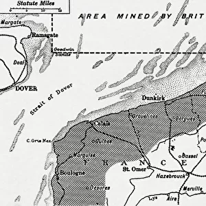
Chart of Dover Strait, c.1587-88 (watercolour on vellum)
")
![]()
Wall Art and Photo Gifts from Fine Art Finder
Chart of Dover Strait, c.1587-88 (watercolour on vellum)
7340491 Chart of Dover Strait, c.1587-88 (watercolour on vellum) by Teixeira, Luis (fl.1564-1612); 40x52 cm; National Maritime Museum, London, UK; (add.info.: Creator: Luis Teixeira
Single sheet. Scale [circa 1:400, 000]. The scales are in Spanish leagues and northern leagues. North is at 225 degrees. This chart of the Strait of Dover contains a latitude bar, one compass radiate and coastal profiles. Soundings and anchorages are shown.
The attribution to Teixera is on stylistic grounds. This is a manuscript copy in Portuguese of No.4 in Waghenaer's printed Spiegel der Zeevaerdt (1584), with a latitude scale added. A similar Portuguese copy (of the English coast from the Isle of Wight to Dover) is in the Prins Hendrik Museum, Rotterdam. They were possibly produced for the 1588 Armada campaign and the planned Spanish invasion of England.); © National Maritime Museum, Greenwich, London
Media ID 38519438
© © National Maritime Museum, Greenwich, London / Bridgeman Images
Dover Kent Watercolors Watercolour Paint C16h
FEATURES IN THESE COLLECTIONS
> Animals
> Birds
> Columbiformes
> Doves
> Related Images
> Animals
> Birds
> Columbiformes
> Doves
> Scaled Dove
> Europe
> Portugal
> Related Images
> Europe
> Republic of Ireland
> Maps
> Europe
> United Kingdom
> England
> Kent
> Dover
> Europe
> United Kingdom
> England
> Kent
> Great Chart
> Europe
> United Kingdom
> England
> Kent
> Related Images
> Fine Art Finder
> Artists
> Luis Teixeira
> Fine Art Finder
> Artists
> Nicholas Comberford
EDITORS COMMENTS
This stunning watercolor print of the Chart of Dover Strait, created by Luis Teixeira in the late 16th century, offers a glimpse into the intricate world of cartography during that time. The detailed map showcases the strategic waterway with precision and artistry, featuring scales in Spanish leagues and northern leagues.
Teixeira's work includes coastal profiles, soundings, anchorages, and a compass radiate to aid sailors navigating through the treacherous waters of the English Channel. The chart is believed to be a manuscript copy in Portuguese of Waghenaer's 'Spiegel der Zeevaerdt,' possibly created for the 1588 Armada campaign and Spain's planned invasion of England.
The vibrant colors used in this piece bring life to an otherwise technical document, highlighting Teixeira's skill as both a cartographer and artist. The addition of a latitude scale further enhances its functionality for seafarers seeking safe passage through one of Europe's busiest maritime routes.
Displayed at the National Maritime Museum in London, this historic artwork serves as a reminder of centuries-old navigation techniques and maritime history. It stands as a testament to human ingenuity and creativity in mapping out our world's oceans with meticulous detail.
MADE IN THE USA
Safe Shipping with 30 Day Money Back Guarantee
FREE PERSONALISATION*
We are proud to offer a range of customisation features including Personalised Captions, Color Filters and Picture Zoom Tools
SECURE PAYMENTS
We happily accept a wide range of payment options so you can pay for the things you need in the way that is most convenient for you
* Options may vary by product and licensing agreement. Zoomed Pictures can be adjusted in the Cart.