Home > Europe > Italy > Sicily > Messina
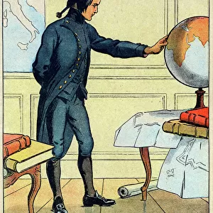
Cartography, 16th century. Map of the Mediterranean Sea, from a portolan chart by Pietro Russo, Messina, 1508 (map)
")
![]()
Wall Art and Photo Gifts from Fine Art Finder
Cartography, 16th century. Map of the Mediterranean Sea, from a portolan chart by Pietro Russo, Messina, 1508 (map)
AIS5350346 Cartography, 16th century. Map of the Mediterranean Sea, from a portolan chart by Pietro Russo, Messina, 1508 (map); Museu Maritim Atarazanas, Barcelona, Catalunya, Spain; © Iberfoto
Media ID 38174552
© © Iberfoto / Bridgeman Images
Mediterranean Sea Navigator Portolan C16h Portolan Chart
FEATURES IN THESE COLLECTIONS
> Animals
> Mammals
> Soricidae
> Navigator
> Europe
> Italy
> Sicily
> Messina
> Europe
> Spain
> Related Images
> Fine Art Finder
> Artists
> Raymond de la Neziere
> Maps and Charts
> Related Images
> Maps and Charts
> Spain
EDITORS COMMENTS
This stunning 16th-century map of the Mediterranean Sea, created by cartographer Pietro Russo in Messina in 1508, is a true masterpiece of historical cartography. The intricate details and vibrant colors used to depict this important maritime region are truly awe-inspiring.
Portolan charts like this one were essential tools for navigators during the Age of Exploration, providing detailed information on coastlines, ports, and navigational routes. This particular map showcases the skill and artistry of Russo, capturing the beauty and complexity of the Mediterranean with precision and accuracy.
As you study this print closely, you can almost imagine yourself sailing through these ancient waters, following in the footsteps of explorers from centuries past. The careful attention to detail in every line and symbol on this map speaks to a time when exploration was both an art form and a science.
Displayed at the Museu Maritim Atarazanas in Barcelona, Spain, this piece is a testament to humanity's enduring fascination with maps and geography. It serves as a reminder of our shared history as seafaring people who have always sought to understand and navigate the world around us.
Whether you're a history buff or simply appreciate fine art, this print is sure to captivate your imagination and transport you back in time to an era when maps were not just tools for navigation but works of art unto themselves.
MADE IN THE USA
Safe Shipping with 30 Day Money Back Guarantee
FREE PERSONALISATION*
We are proud to offer a range of customisation features including Personalised Captions, Color Filters and Picture Zoom Tools
SECURE PAYMENTS
We happily accept a wide range of payment options so you can pay for the things you need in the way that is most convenient for you
* Options may vary by product and licensing agreement. Zoomed Pictures can be adjusted in the Cart.