Home > North America > United States of America > New York > New York > Maps
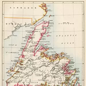
Civil War Railroad Map, 1862

![]()
Wall Art and Photo Gifts from Fine Art Finder
Civil War Railroad Map, 1862
2902811 Civil War Railroad Map, 1862; (add.info.: New railroad map of the middle states including New York, New Jersey, Pennsylvania, Delaware, Maryland, Ohio and Canada.); Buyenlarge Archive/UIG
Media ID 38414578
© Buyenlarge Archive/UIG / Bridgeman Images
1860s Cartographic Civil War Federal Railroad Union
FEATURES IN THESE COLLECTIONS
> Fine Art Finder
> Artists
> Raymond de la Neziere
> North America
> Canada
> Maps
> North America
> Canada
> Related Images
> North America
> United States of America
> Delaware
> Related Images
> North America
> United States of America
> Maps
> North America
> United States of America
> Maryland
> Related Images
> North America
> United States of America
> New Jersey
> Related Images
> North America
> United States of America
> New York
> New York
> Maps
> North America
> United States of America
> New York
> Related Images
> North America
> United States of America
> Ohio
> Related Images
EDITORS COMMENTS
This stunning print captures a piece of history with the Civil War Railroad Map from 1862. The intricate details and careful craftsmanship of this map showcase the importance of railways during this tumultuous time in American history.
The map covers the middle states, including New York, New Jersey, Pennsylvania, Delaware, Maryland, Ohio, and Canada. It provides a glimpse into the transportation infrastructure that played a crucial role in the movement of troops and supplies during the Civil War.
As you study this map closely, you can see how railroads connected major cities and strategic locations across these states. The intricate network of tracks symbolizes unity and cooperation as different regions worked together to support the Union cause.
This piece is not just a cartographic representation but also a historical artifact that tells a story of resilience and determination. It serves as a reminder of the challenges faced by both sides during one of America's darkest periods.
Whether you are a history buff or simply appreciate fine art, this print is sure to spark curiosity and admiration for the ingenuity displayed in creating such an essential tool for navigating through turbulent times.
MADE IN THE USA
Safe Shipping with 30 Day Money Back Guarantee
FREE PERSONALISATION*
We are proud to offer a range of customisation features including Personalised Captions, Color Filters and Picture Zoom Tools
SECURE PAYMENTS
We happily accept a wide range of payment options so you can pay for the things you need in the way that is most convenient for you
* Options may vary by product and licensing agreement. Zoomed Pictures can be adjusted in the Cart.