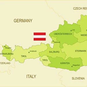
Home > Europe > Austria > Maps
Geographic map of Europe in the 1870s. 19th century colour lithography

![]()
Wall Art and Photo Gifts from Fine Art Finder
Geographic map of Europe in the 1870s. 19th century colour lithography
NWI4868470 Geographic map of Europe in the 1870s. 19th century colour lithography; (add.info.: Geographic map of Europe in the 1870s. 19th century colour lithography); Photo © North Wind Pictures
Media ID 38100690
© Photo © North Wind Pictures / Bridgeman Images
East Prussia Geographical Map Prussia Prussian Prussians
FEATURES IN THESE COLLECTIONS
> Europe
> Austria
> Related Images
> Fine Art Finder
> Artists
> Raymond de la Neziere
> Maps and Charts
> Early Maps
EDITORS COMMENTS
This stunning 19th-century color lithograph print showcases a detailed geographic map of Europe in the 1870s. The intricate details and vibrant colors bring to life the various countries and regions that make up the continent during this time period.
From Germany to France, Austria to Prussia, and Russia to Asia, each country is clearly labeled and delineated on the map. The engraving work is meticulous, capturing every border and coastline with precision.
As you study this historical map, you can't help but be transported back in time to an era when European nations were undergoing significant political and social changes. The divisions between different empires and kingdoms are evident, reflecting the complex geopolitical landscape of the late 19th century.
Whether you're a history buff or simply appreciate fine art, this print offers a fascinating glimpse into Europe's past. It serves as a reminder of how much has changed over the decades while also highlighting some enduring cultural identities that continue to shape our world today.
Add this Geographic Map of Europe in the 1870s print to your collection for a touch of vintage charm and historical intrigue.
MADE IN THE USA
Safe Shipping with 30 Day Money Back Guarantee
FREE PERSONALISATION*
We are proud to offer a range of customisation features including Personalised Captions, Color Filters and Picture Zoom Tools
SECURE PAYMENTS
We happily accept a wide range of payment options so you can pay for the things you need in the way that is most convenient for you
* Options may vary by product and licensing agreement. Zoomed Pictures can be adjusted in the Cart.