Home > Africa > Libya > Maps
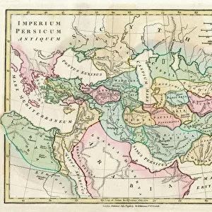
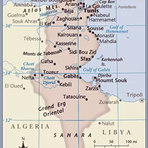
Map of Africa: This map by Nicolas Sanson d'Abbeville (1600-1667) depicts the kingdoms of Tunis and Tripoli. 1656 Municipal Library of Marseille
 depicts the kingdoms of Tunis and Tripoli. 1656 Municipal Library of Marseille")
![]()
Wall Art and Photo Gifts from Fine Art Finder
Map of Africa: This map by Nicolas Sanson d'Abbeville (1600-1667) depicts the kingdoms of Tunis and Tripoli. 1656 Municipal Library of Marseille
JEB4874533 Map of Africa: This map by Nicolas Sanson d'Abbeville (1600-1667) depicts the kingdoms of Tunis and Tripoli. 1656 Municipal Library of Marseille; (add.info.: Map of Africa: This map by Nicolas Sanson d'Abbeville (1600-1667) depicts the kingdoms of Tunis and Tripoli. 1656 Municipal Library of Marseille); © Jean Bernard. All rights reserved 2024
Media ID 38100706
© © Jean Bernard. All rights reserved 2024 / Bridgeman Images
Arab Country Libya Libyan Maghrebin Maghrebine North African Tripolite Tunis Tunisia Tunisian 17th Centuries Africa African African Arab Civilization Arab Culture Arabians Geographical Map Jeanbernard Maghreb Maghrebi Maghrebian
FEATURES IN THESE COLLECTIONS
> Africa
> Libya
> Related Images
> Africa
> Tunisia
> Related Images
> Fine Art Finder
> Artists
> Raymond de la Neziere
> Maps and Charts
> Early Maps
EDITORS COMMENTS
This stunning print of a map of Africa by Nicolas Sanson d'Abbeville offers a glimpse into the intricate and detailed cartography of the 17th century. Created in 1656, this map specifically focuses on the kingdoms of Tunis and Tripoli, showcasing the rich history and geography of North Africa.
The vibrant colors used in this engraving bring to life the diverse landscapes and cultures that make up this region. From the bustling cities to the vast deserts, each area is meticulously depicted with precision and care.
As we study this map, we are transported back in time to an era when exploration and discovery were at the forefront of human curiosity. The intricate borders and labels provide valuable insight into how Europeans viewed African territories during this period.
It is fascinating to see how much has changed since then, yet also how much has remained constant. The legacy of Arab civilization in North Africa is still evident today, as these regions continue to be integral parts of the African continent.
Overall, this print serves as a beautiful reminder of both our shared history and our enduring fascination with maps as windows into different worlds.
MADE IN THE USA
Safe Shipping with 30 Day Money Back Guarantee
FREE PERSONALISATION*
We are proud to offer a range of customisation features including Personalised Captions, Color Filters and Picture Zoom Tools
SECURE PAYMENTS
We happily accept a wide range of payment options so you can pay for the things you need in the way that is most convenient for you
* Options may vary by product and licensing agreement. Zoomed Pictures can be adjusted in the Cart.