Home > Europe > United Kingdom > England > London > Museums > National Maritime Museum
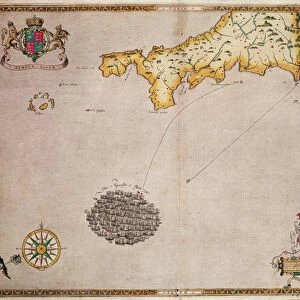
Americae Sive Novi Orbis, Nova Descriptio (The Americas or the New World, newly described), 1573 (copperplate engraving on paper)
, 1573 (copperplate engraving on paper)")
![]()
Wall Art and Photo Gifts from Fine Art Finder
Americae Sive Novi Orbis, Nova Descriptio (The Americas or the New World, newly described), 1573 (copperplate engraving on paper)
7340118 Americae Sive Novi Orbis, Nova Descriptio (The Americas or the New World, newly described), 1573 (copperplate engraving on paper) by Ortelius, Abraham (1527-98); 42x53 cm; National Maritime Museum, London, UK; (add.info.: Creator: Abraham Ortelius
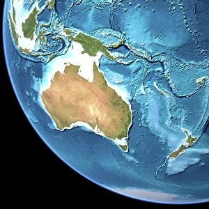
An atlas sheet from an edition of Theatrum Orbis Terrarum with Latin text, published in 1573, it's a hand coloured copperplate engraving. This hemispherical map shows North and South America and the Great Southern Continent extending northward to include New Guinea. The title is in a strapwork cartouche and the sea area is decorated with four ships and a sea creature.); © National Maritime Museum, Greenwich, London
Media ID 38371918
© © National Maritime Museum, Greenwich, London / Bridgeman Images
FEATURES IN THESE COLLECTIONS
> Arts
> Artists
> O
> Abraham Ortelius
> Europe
> United Kingdom
> England
> London
> Boroughs
> Greenwich
> Europe
> United Kingdom
> England
> London
> Museums
> Greenwich Heritage Centre
> Europe
> United Kingdom
> England
> London
> Museums
> National Maritime Museum
> Europe
> United Kingdom
> England
> London
> Towns
> Greenwich
> Europe
> United Kingdom
> Heritage Sites
> Maritime Greenwich
> Europe
> United Kingdom
> Maps
> Fine Art Finder
> Artists
> Abraham Ortelius
> Fine Art Finder
> Artists
> Robert (after) Adams
> Maps and Charts
> World
EDITORS COMMENTS
This stunning copperplate engraving from 1573, titled Americae Sive Novi Orbis, Nova Descriptio (The Americas or the New World, newly described), by Abraham Ortelius, offers a fascinating glimpse into the cartography of the 16th century. The hand-colored map showcases North and South America, as well as the Great Southern Continent extending northward to include New Guinea.
Ortelius's meticulous attention to detail is evident in every aspect of this hemispherical map - from the intricate strapwork cartouche framing the title to the decorative ships and sea creature adorning the oceanic expanse. This piece is not just a geographical representation but also a work of art in its own right.
As we gaze upon this historical artifact housed at the National Maritime Museum in London, we are transported back in time to an era when exploration and discovery were at their peak. The vibrant colors and intricate engravings serve as a testament to Ortelius's skill as both a geographer and an artist.
Whether you're a history buff, a lover of maps, or simply appreciate fine craftsmanship, this print is sure to captivate your imagination and spark your curiosity about the early days of cartography.
MADE IN THE USA
Safe Shipping with 30 Day Money Back Guarantee
FREE PERSONALISATION*
We are proud to offer a range of customisation features including Personalised Captions, Color Filters and Picture Zoom Tools
SECURE PAYMENTS
We happily accept a wide range of payment options so you can pay for the things you need in the way that is most convenient for you
* Options may vary by product and licensing agreement. Zoomed Pictures can be adjusted in the Cart.