Home > Africa > Cape Verde > Maps
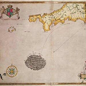
A chart of the seacoasts from the Landsend of England to Cape Bona Esperanca, 1675 (engraving)
")
![]()
Wall Art and Photo Gifts from Fine Art Finder
A chart of the seacoasts from the Landsend of England to Cape Bona Esperanca, 1675 (engraving)
7340048 A chart of the seacoasts from the Landsend of England to Cape Bona Esperanca, 1675 (engraving) by Seller, John (1632-97); 45x55.5 cm; National Maritime Museum, London, UK; (add.info.: Creator: John Seller; John Darby
A hand coloured engraving, scale: circa 1:18 000 000 (bar). There's a cartographic note of, North at 270 degrees. The borders are graduated for latitude, the bar scales are in English and French leagues, Dutch miles and Spanish leagues. It also shows the recommended sailing channel midway between Brasil and Cape Verde and is decorated with the coat of arms of the Royal Africa Company, which had been chartered in 1672. It's a chart from Atlas Maritimus, or the Sea Atlas; being a book of maritime charts.); © National Maritime Museum, Greenwich, London
Media ID 38177546
© © National Maritime Museum, Greenwich, London / Bridgeman Images
FEATURES IN THESE COLLECTIONS
> Africa
> Cape Verde
> Maps
> Africa
> Cape Verde
> Related Images
> Arts
> Artists
> S
> John Seller
> Europe
> France
> Sport
> Sailing
> Europe
> Republic of Ireland
> Maps
> Europe
> United Kingdom
> England
> London
> Boroughs
> Greenwich
> Europe
> United Kingdom
> England
> London
> Museums
> British Museum
> Europe
> United Kingdom
> England
> London
> Museums
> Greenwich Heritage Centre
> Fine Art Finder
> Artists
> John Seller
> Fine Art Finder
> Artists
> Robert (after) Adams
EDITORS COMMENTS
This stunning engraving from 1675 by John Seller captures the intricate details of the seacoasts from Landsend, England to Cape Bona Esperanca. The chart, part of the 'Atlas Maritimus', is a true masterpiece of maritime cartography, showcasing not only the geography but also the recommended sailing channels and navigational information for sailors of that time.
The hand-colored engraving features a scale of approximately 1:18,000,000 and includes bar scales in English and French leagues, Dutch miles, and Spanish leagues. It even shows the coat of arms of the Royal Africa Company, adding a touch of historical significance to this already remarkable piece.
With borders graduated for latitude and a cartographic note indicating North at 270 degrees, this chart is both informative and visually captivating. The attention to detail in depicting coastlines, shorelines, and sea routes reflects Seller's skill as an engraver during the seventeenth century.
As you gaze upon this print hanging on your wall, you can't help but be transported back in time to an era when exploration and navigation were at their peak. Let this enchanting artwork serve as a reminder of our enduring fascination with maps and maritime history.
MADE IN THE USA
Safe Shipping with 30 Day Money Back Guarantee
FREE PERSONALISATION*
We are proud to offer a range of customisation features including Personalised Captions, Color Filters and Picture Zoom Tools
SECURE PAYMENTS
We happily accept a wide range of payment options so you can pay for the things you need in the way that is most convenient for you
* Options may vary by product and licensing agreement. Zoomed Pictures can be adjusted in the Cart.