Home > Animals > Mammals > Soricidae > Navigator
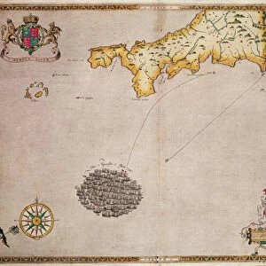
A plan of the road and harbour of Fowey or Foy by Lieutenant James Cook of the Royal Navy, 1779 (copperplate engraving)
")
![]()
Wall Art and Photo Gifts from Fine Art Finder
A plan of the road and harbour of Fowey or Foy by Lieutenant James Cook of the Royal Navy, 1779 (copperplate engraving)
7340127 A plan of the road and harbour of Fowey or Foy by Lieutenant James Cook of the Royal Navy, 1779 (copperplate engraving) by British School, (18th Century); 73x54 cm; National Maritime Museum, London, UK; (add.info.: Creator: Robert Sayer; John Bennett
This chart is bound in Sayer and Bennett's A Complete Channel Pilot, comprehending the English and French coasts, from the Thames mouth to the Bay of Biscay, including the North Sea, with sailing directions. It's a copperplate engraving.); © National Maritime Museum, Greenwich, London
Media ID 38412526
© © National Maritime Museum, Greenwich, London / Bridgeman Images
Boat Dock Capitain Cook Captain James Cook Coast Line Cornwall Harbor Area Harbour Area Harbours Harbourside James Cook Lane Navigator Port Area Shorelines Stratagem Strategy 18e Siecle 18th Century 18th Centuries Marines Maritime Force Naval Force Naval Infantry Seawater
FEATURES IN THESE COLLECTIONS
> Animals
> Mammals
> Soricidae
> Navigator
> Arts
> Artists
> B
> James Bayes
> Arts
> Artists
> I
> Irish School Irish School
> Arts
> Artists
> R
> James Roberts
> Arts
> Artists
> S
> James Sayers
> Arts
> Artists
> W
> John White
> Arts
> Artists
> W
> Robert White
> Europe
> France
> Sport
> Sailing
> Europe
> Republic of Ireland
> Maps
> Fine Art Finder
> Artists
> British School
> Fine Art Finder
> Artists
> Robert (after) Adams
EDITORS COMMENTS
This stunning copperplate engraving from 1779 showcases a detailed plan of the road and harbour of Fowey or Foy, created by Lieutenant James Cook of the Royal Navy. The intricate lines and markings on this map provide a fascinating glimpse into the navigational tools used during the 18th century.
Bound in Sayer and Bennett's 'A Complete Channel Pilot', this chart offers sailing directions for sailors navigating the English and French coasts, from the Thames mouth to the Bay of Biscay. The expertise and precision required to create such a comprehensive guide is evident in every line etched onto this print.
As you study this historical artifact, you can almost imagine Captain James Cook himself meticulously plotting out each detail to aid fellow seafarers on their journeys. The legacy of exploration and discovery left behind by individuals like Cook is beautifully preserved in prints like these, allowing us to connect with the past and appreciate the advancements made in cartography over time.
This piece from National Maritime Museum in London serves as both a work of art and an invaluable historical document, offering a window into maritime navigation techniques of centuries past. It stands as a testament to human ingenuity and curiosity that continues to drive exploration forward today.
MADE IN THE USA
Safe Shipping with 30 Day Money Back Guarantee
FREE PERSONALISATION*
We are proud to offer a range of customisation features including Personalised Captions, Color Filters and Picture Zoom Tools
SECURE PAYMENTS
We happily accept a wide range of payment options so you can pay for the things you need in the way that is most convenient for you
* Options may vary by product and licensing agreement. Zoomed Pictures can be adjusted in the Cart.