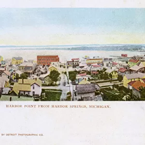
Home > North America > United States of America > Lakes > Lake Huron
The establishment of French colonies in the Great Lakes region, circa 1600. Map of the French Jesuites Jacques Marquette (1637-1675) and Louis Jolliet (1645-1700) of Lakes Superior, Michigan and Huron, Michigan and Wisconsin (United States)
 and Louis Jolliet (1645-1700) of Lakes Superior, Michigan and Huron, Michigan and Wisconsin (United States)")
![]()
Wall Art and Photo Gifts from Fine Art Finder
The establishment of French colonies in the Great Lakes region, circa 1600. Map of the French Jesuites Jacques Marquette (1637-1675) and Louis Jolliet (1645-1700) of Lakes Superior, Michigan and Huron, Michigan and Wisconsin (United States)
NWI4850096 The establishment of French colonies in the Great Lakes region, circa 1600. Map of the French Jesuites Jacques Marquette (1637-1675) and Louis Jolliet (1645-1700) of Lakes Superior, Michigan and Huron, Michigan and Wisconsin (United States). Color lithography, 19th century, based on a 17th century map.; (add.info.: The establishment of French colonies in the Great Lakes region, circa 1600. Map of the French Jesuites Jacques Marquette (1637-1675) and Louis Jolliet (1645-1700) of Lakes Superior, Michigan and Huron, Michigan and Wisconsin (United States). Color lithography, 19th century, based on a 17th century map.); Photo © North Wind Pictures
Media ID 38166158
© © North Wind Pictures / Bridgeman Images
FEATURES IN THESE COLLECTIONS
> Europe
> France
> Lakes
> Related Images
> Fine Art Finder
> Artists
> Roman
> North America
> United States of America
> Lakes
> Lake Huron
> North America
> United States of America
> Lakes
> Lake Michigan
> North America
> United States of America
> Lakes
> Lake Superior
> North America
> United States of America
> Lakes
> Related Images
> North America
> United States of America
> Maps
> North America
> United States of America
> Michigan
> Related Images
EDITORS COMMENTS
This stunning print captures the establishment of French colonies in the Great Lakes region circa 1600. The map, created by French Jesuites Jacques Marquette and Louis Jolliet, showcases Lakes Superior, Michigan, Huron, and Wisconsin in intricate detail.
The color lithography from the 19th century is based on a 17th-century map, providing a glimpse into the historical significance of this period. The vibrant colors bring to life the exploration and colonization efforts of the French in North America.
As we study this map, we are transported back in time to an era of discovery and conquest. The detailed engravings highlight key geographical features and settlements established by the French during this pivotal moment in history.
From France to America's shores, this map symbolizes the spirit of colonialism that shaped nations and cultures for centuries to come. It serves as a reminder of the brave explorers who ventured into unknown territories in search of new lands and opportunities.
Through this photo print, we can appreciate not only the artistry involved but also gain insight into how European powers expanded their influence across continents. It stands as a testament to human curiosity and ambition that continues to drive us forward today.
MADE IN THE USA
Safe Shipping with 30 Day Money Back Guarantee
FREE PERSONALISATION*
We are proud to offer a range of customisation features including Personalised Captions, Color Filters and Picture Zoom Tools
SECURE PAYMENTS
We happily accept a wide range of payment options so you can pay for the things you need in the way that is most convenient for you
* Options may vary by product and licensing agreement. Zoomed Pictures can be adjusted in the Cart.