Home > Europe > United Kingdom > England > London > Museums > Design Museum
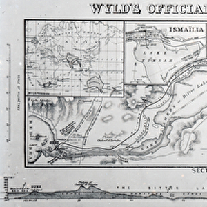
Chart of the Gulf of Finland and Baltic Sea, 1854 (engraving)
")
![]()
Wall Art and Photo Gifts from Fine Art Finder
Chart of the Gulf of Finland and Baltic Sea, 1854 (engraving)
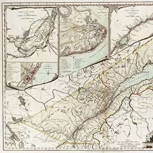
7339451 Chart of the Gulf of Finland and Baltic Sea, 1854 (engraving) by Wyld, James the Younger (1812-87); 50x67 cm; National Maritime Museum, London, UK; (add.info.: Creator: James Wyld
The Gulf of Finland and Baltic Sea with the fortified places from Stockholm to St Petersburg and the Aland Islands designed to show the operations of the British & French fleets by geographer to the Queen and HRH Prince Albert. The coastlines and territorial borders are coloured, defences and key places are inked red.
Scale circa 1:1,000,000, graduated and in English miles, nautic miles and Russian versts. Contains insets showing the Gulf of Bothnia as a general chart. Also, Cronstadt with the fortifications and batteries, circa 1:85,000, Cronstadt and St. Petersburg from Russian surveys circa 1:400,000. The harbour and entrances of Sweaborg and Helsingfors with the fortifications and batteries circa 1:55,000.); © National Maritime Museum, Greenwich, London
Media ID 38176960
© © National Maritime Museum, Greenwich, London / Bridgeman Images
FEATURES IN THESE COLLECTIONS
> Europe
> Finland
> Related Images
> Europe
> United Kingdom
> England
> London
> Boroughs
> Greenwich
> Europe
> United Kingdom
> England
> London
> Museums
> British Museum
> Europe
> United Kingdom
> England
> London
> Museums
> Design Museum
> Europe
> United Kingdom
> England
> London
> Museums
> Greenwich Heritage Centre
> Europe
> United Kingdom
> England
> London
> Museums
> National Maritime Museum
> Fine Art Finder
> Artists
> James the Younger Wyld
> Fine Art Finder
> Artists
> Sayer & Bennett
EDITORS COMMENTS
This stunning engraving by James Wyld the Younger from 1854 captures the intricate details of the Chart of the Gulf of Finland and Baltic Sea. Measuring 50x67 cm, this historical piece is housed in the National Maritime Museum in London, UK.
The map showcases the fortified places from Stockholm to St Petersburg, as well as the Aland Islands, providing a detailed view of key locations along these coastlines. The borders and defences are highlighted in red ink, adding a pop of color to this otherwise monochromatic print.
Created for Queen Victoria and HRH Prince Albert by geographer James Wyld, this chart features a scale of approximately 1:1,000,000 with measurements in English miles, nautical miles, and Russian versts. Insets showing specific areas such as Cronstadt with fortifications and batteries offer even more insight into strategic military positions during that time period.
Overall, this engraving serves not only as a beautiful piece of art but also as an important historical document showcasing naval operations in the region. Its meticulous detail and precision make it a valuable addition to any collection or display.
MADE IN THE USA
Safe Shipping with 30 Day Money Back Guarantee
FREE PERSONALISATION*
We are proud to offer a range of customisation features including Personalised Captions, Color Filters and Picture Zoom Tools
SECURE PAYMENTS
We happily accept a wide range of payment options so you can pay for the things you need in the way that is most convenient for you
* Options may vary by product and licensing agreement. Zoomed Pictures can be adjusted in the Cart.