Home > Arts > Artists > Related Images
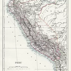
Map of Central America in the 16th century: above it shows the regions of Peru

![]()
Wall Art and Photo Gifts from Fine Art Finder
Map of Central America in the 16th century: above it shows the regions of Peru
GIA4805198 Map of Central America in the 16th century: above it shows the regions of Peru, Amazon and Bogota (Panama, Colombia and Venezuela). by Unknown Artist, (16th century); Private Collection; (add.info.: Map of Central America in the 16th century: the regions of Peru, Amazon and Bogota (Panama, Colombia and Venezuela)); eGiancarlo Costa; out of copyright
Media ID 22829202
© Giancarlo Costa / Bridgeman Images
Central America Colombia Colombian Geographical Map Venezuela Venezuelan
FEATURES IN THESE COLLECTIONS
> Arts
> Artists
> Related Images
> Fine Art Finder
> Artists
> Spanish School (after)
> Fine Art Finder
> Artists
> Unknown Artist
> Maps and Charts
> Related Images
> North America
> Panama
> Maps
> North America
> Panama
> Related Images
> South America
> Colombia
> Bogota
> South America
> Colombia
> Maps
> South America
> Colombia
> Related Images
> South America
> Peru
> Maps
> South America
> Peru
> Related Images
EDITORS COMMENTS
This print showcases a remarkable map of Central America in the 16th century. The artist behind this masterpiece remains unknown, but their talent and attention to detail are evident. Displayed above the map are regions including Peru, Amazon, and Bogota, representing present-day Panama, Colombia, and Venezuela respectively. The intricate lines and vibrant colors on this ancient map transport us back in time to an era of exploration and discovery. It serves as a visual testament to the rich history and cultural heritage of these lands. As we gaze upon it, we can almost imagine the intrepid explorers who ventured through dense jungles and treacherous terrains to chart these uncharted territories. This particular print is part of a private collection that has preserved its beauty for generations to come. Its historical significance cannot be overstated; it offers invaluable insights into the geographical landscape of South America during this period. Giancarlo Costa has skillfully captured this piece with his camera lens, ensuring that its details remain vividly visible even after centuries have passed. This photograph is now available for all art enthusiasts to appreciate without any copyright restrictions. Let this mesmerizing image transport you back in time as you explore the diverse landscapes depicted on this 16th-century map – from the majestic peaks of Peru to the lush rainforests of Amazon and beyond – revealing a world waiting to be discovered.
MADE IN THE USA
Safe Shipping with 30 Day Money Back Guarantee
FREE PERSONALISATION*
We are proud to offer a range of customisation features including Personalised Captions, Color Filters and Picture Zoom Tools
SECURE PAYMENTS
We happily accept a wide range of payment options so you can pay for the things you need in the way that is most convenient for you
* Options may vary by product and licensing agreement. Zoomed Pictures can be adjusted in the Cart.