Home > Asia > Armenia > Maps
Maps of Russia from 1462 to 1689 (left) and map of territories added to the Russian Empire (right) from 1689 to 1825, with a map of Armenia and the Caucasus region (center) - 19th century Lithography (Russia 1462-1689 (left)
 and map of territories added to the Russian Empire (right) from 1689 to 1825, with a map of Armenia and the Caucasus region (center) - 19th century Lithography (Russia 1462-1689 (left)")
![]()
Wall Art and Photo Gifts from Fine Art Finder
Maps of Russia from 1462 to 1689 (left) and map of territories added to the Russian Empire (right) from 1689 to 1825, with a map of Armenia and the Caucasus region (center) - 19th century Lithography (Russia 1462-1689 (left)
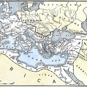
NWI4872109 Maps of Russia from 1462 to 1689 (left) and map of territories added to the Russian Empire (right) from 1689 to 1825, with a map of Armenia and the Caucasus region (center) - 19th century Lithography (Russia 1462-1689 (left); lands added to Russian Empire 1689-1825 (right), plus Armenia and Caucasia (inset) Color lithograph of a 19th century illustration); (add.info.: Maps of Russia from 1462 to 1689 (left) and map of territories added to the Russian Empire (right) from 1689 to 1825, with a map of Armenia and the Caucasus region (center) - 19th century Lithography (Russia 1462-1689 (left); lands added to Russian Empire 1689-1825 (right), plus Armenia and Caucasia (inset) Color lithograph of a 19th century illustration)); Photo © North Wind Pictures
Media ID 38335578
© © North Wind Pictures / Bridgeman Images
Armenia Armenian Caucasus Geographical Map
FEATURES IN THESE COLLECTIONS
> Asia
> Armenia
> Related Images
> Europe
> Armenia
> Related Images
> Fine Art Finder
> Artists
> Spanish School (after)
EDITORS COMMENTS
This stunning lithograph print showcases the evolution of Russia's territorial expansion from 1462 to 1825, with a focus on the addition of lands to the Russian Empire. The map on the left depicts Russia's boundaries from 1462 to 1689, showing its growth and development over time. On the right, we see the territories added to the Russian Empire between 1689 and 1825, highlighting the country's continued expansion into new regions.
In the center of this historical display is a detailed map of Armenia and the Caucasus region, providing insight into these culturally rich areas during this period. The intricate details and vibrant colors in this lithograph bring these maps to life, offering a glimpse into Russia's past and its influence on neighboring territories.
As we study these maps, we are reminded of Russia's complex history and its impact on surrounding regions. From political conquests to cultural exchanges, each line and boundary tells a story of power dynamics and shifting alliances throughout centuries gone by.
This lithograph print serves as a valuable educational tool for understanding Russia's geopolitical landscape during this transformative era. It invites us to explore not only geographical changes but also social interactions that have shaped our world today.
MADE IN THE USA
Safe Shipping with 30 Day Money Back Guarantee
FREE PERSONALISATION*
We are proud to offer a range of customisation features including Personalised Captions, Color Filters and Picture Zoom Tools
SECURE PAYMENTS
We happily accept a wide range of payment options so you can pay for the things you need in the way that is most convenient for you
* Options may vary by product and licensing agreement. Zoomed Pictures can be adjusted in the Cart.