Home > North America > Turks and Caicos > Maps
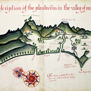
Map of Guanahani or San Salvador showing Watling Island where Christopher Columbus made landfall in 1492. From the book Life of Christopher Columbus by Clements R. Markham published 1892

![]()
Wall Art and Photo Gifts from Fine Art Finder
Map of Guanahani or San Salvador showing Watling Island where Christopher Columbus made landfall in 1492. From the book Life of Christopher Columbus by Clements R. Markham published 1892
2915316 Map of Guanahani or San Salvador showing Watling Island where Christopher Columbus made landfall in 1492. From the book Life of Christopher Columbus by Clements R. Markham published 1892.; Photo © Hilary Morgan
Media ID 38413748
© © Hilary Morgan / Bridgeman Images
1492 Bahamas Chart Christopher Colon Columbus Cristobal Cristoval Domestic Cat Geographical Grand Kitten Kittens Mapmaking Salvador Caicos Guanahani Landfall Samana Turk Watling
FEATURES IN THESE COLLECTIONS
> Animals
> Mammals
> Cats (Domestic)
> Related Images
> Fine Art Finder
> Artists
> Swiss School
> Maps and Charts
> World
> North America
> The Bahamas
> Maps
> North America
> The Bahamas
> Related Images
> North America
> El Salvador
> Maps
> North America
> El Salvador
> San Salvador
> North America
> Turks and Caicos
> Maps
EDITORS COMMENTS
This stunning print of the Map of Guanahani or San Salvador, showing Watling Island where Christopher Columbus made his historic landfall in 1492, is a captivating piece of history captured in intricate detail. The map, taken from the book "Life of Christopher Columbus" by Clements R. Markham and published in 1892, offers a glimpse into the world as it was perceived during that monumental moment in time.
The careful craftsmanship and artistry involved in creating this map are evident in every line and symbol, showcasing the skill and dedication of cartographers from centuries past. The geographical features of Bahama islands like Grand Turk, Mayaguana, Samana Cay, and more are meticulously depicted, providing a comprehensive view of the area where Columbus first set foot on what would later be known as the New World.
As you study this map closely, you can almost imagine the excitement and anticipation felt by Columbus and his crew as they approached these unfamiliar shores over five centuries ago. It serves as a tangible reminder of the courage and curiosity that drove explorers to venture into unknown territories, forever changing the course of history. This print is not just a representation of geographic locations; it is a testament to human ingenuity and exploration that continues to inspire us today.
MADE IN THE USA
Safe Shipping with 30 Day Money Back Guarantee
FREE PERSONALISATION*
We are proud to offer a range of customisation features including Personalised Captions, Color Filters and Picture Zoom Tools
SECURE PAYMENTS
We happily accept a wide range of payment options so you can pay for the things you need in the way that is most convenient for you
* Options may vary by product and licensing agreement. Zoomed Pictures can be adjusted in the Cart.