Home > Animals > Birds > Apodiformes > Hummingbirds > Black Inca
Map of Mexico and Peru, showing the Aztec Empire and the Inca Empire. (print)
")
![]()
Wall Art and Photo Gifts from Fine Art Finder
Map of Mexico and Peru, showing the Aztec Empire and the Inca Empire. (print)
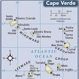
7420055 Map of Mexico and Peru, showing the Aztec Empire and the Inca Empire. (print); (add.info.: Map of Mexico and Peru, showing the Aztec Empire and the Inca Empire. Also shown is the black line down the right hand side of the map denoting The Treaty of Tordesillas, 1494, which divided the newly discovered lands outside Europe between the Portuguese Empire and the Spanish Empire (Crown of Castile), along a meridian 370 leagues west of the Cape Verde islands, off the west coast of Africa. That line of demarcation was about halfway between the Cape Verde islands (already Portuguese) and the islands visited by Christopher Columbus on his first voyage (claimed for Castile and Leon), named in the treaty as Cipangu and Antillia (Cuba and Hispaniola). This Treaty modified an earlier division proposed by Pope Alexander VI which was known as the Pope's Line. All territory west of it was given to Spain. From the book Outline of History by H.G. Wells, published 1920.); Photo © Ken Welsh. All rights reserved 2024
Media ID 38177512
© © Ken Welsh. All rights reserved 2024 / Bridgeman Images
Ageing Chart Diagram Graph Latin America Mexicans Mexico Mexican Peru Peru Peruvian Peruvian Peruvian Culture Peruvians Run Down 15th 15 Xv Xvth Fifteenth Century Geographer Latine America
FEATURES IN THESE COLLECTIONS
> Africa
> Cape Verde
> Maps
> Africa
> Cape Verde
> Related Images
> Africa
> South Africa
> Maps
> Africa
> South Africa
> Related Images
> Animals
> Birds
> Apodiformes
> Hummingbirds
> Black Inca
> Europe
> Portugal
> Related Images
> Fine Art Finder
> Artists
> Thomas Goldsworth Dutton
> Historic
> Ancient civilizations
> Aztec Empire
EDITORS COMMENTS
This stunning print showcases a detailed map of Mexico and Peru, highlighting the vast empires of the Aztec and Inca civilizations. The intricate borders and territories of these ancient empires are clearly depicted, giving us a glimpse into the rich history and culture of these indigenous peoples.
What makes this print even more fascinating is the inclusion of the black line representing The Treaty of Tordesillas in 1494. This historic agreement divided newly discovered lands outside Europe between the Portuguese Empire and the Spanish Empire (Crown of Castile). The line demarcates where each empire's influence would extend, with all territory west belonging to Spain.
The significance of this treaty is further emphasized by its modification from an earlier division proposed by Pope Alexander VI known as the Pope's Line. This map serves as a visual representation of how political agreements shaped colonial expansion during this period in history.
Overall, this print not only captures the geographical landscape of Mexico and Peru during pre-Columbian times but also sheds light on the complex power dynamics that influenced European exploration and conquest in the New World. It is a valuable piece for anyone interested in understanding the historical context behind these ancient civilizations and their interactions with European powers.
MADE IN THE USA
Safe Shipping with 30 Day Money Back Guarantee
FREE PERSONALISATION*
We are proud to offer a range of customisation features including Personalised Captions, Color Filters and Picture Zoom Tools
SECURE PAYMENTS
We happily accept a wide range of payment options so you can pay for the things you need in the way that is most convenient for you
* Options may vary by product and licensing agreement. Zoomed Pictures can be adjusted in the Cart.