Home > Animals > Mammals > Cercopithecidae > Mauritius
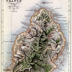
Geographic map of Mauritius (Anc. Ile de France) - engraving, 1838
 - engraving, 1838")
![]()
Wall Art and Photo Gifts from Fine Art Finder
Geographic map of Mauritius (Anc. Ile de France) - engraving, 1838
LSE4099757 Geographic map of Mauritius (Anc. Ile de France) - engraving, 1838 by French School, (19th century); Private Collection; (add.info.: Geographic map of Mauritius (Anc. Ile de France) - engraving, 1838); Photo eLeonard de Selva; French, out of copyright
Media ID 23696720
© Leonard de Selva / Bridgeman Images
Mascareignes Islands Mauritius Geographical Map
FEATURES IN THESE COLLECTIONS
> Africa
> Mauritius
> Related Images
> Africa
> Related Images
> Animals
> Mammals
> Cercopithecidae
> Mauritius
> Fine Art Finder
> Artists
> French School
> Fine Art Finder
> Artists
> Unknown Artist
> Maps and Charts
> Related Images
EDITORS COMMENTS
This print showcases a remarkable engraving from 1838, depicting the geographic map of Mauritius (Anc. Ile de France). Created by an anonymous French School artist in the 19th century, this intricate piece is now part of a private collection. The detailed map offers a glimpse into the historical significance and geographical features of this enchanting island. Mauritius, formerly known as Ile de France, is beautifully illustrated with precision and artistry. Every contour and coastline are meticulously engraved, capturing the essence of its natural splendor. From the Mascareignes Islands to its African roots, this map highlights Mauritius' unique position within Africa's geography. Leonard de Selva skillfully captures this extraordinary artwork through his lens, preserving it for generations to come. His photograph allows us to appreciate not only the craftsmanship behind the original engraving but also serves as a testament to Mauritius' rich history. As we delve into this visual treasure trove, we are transported back in time to witness how cartography was used as both an artistic expression and a tool for exploration. This print invites us to explore every nook and cranny of Mauritius' topography while igniting our curiosity about its cultural heritage. Whether you're an avid collector or simply captivated by historical maps, Leonard de Selva's photograph offers an exquisite window into Mauritius' past that will undoubtedly leave you yearning for more knowledge about this fascinating island paradise.
MADE IN THE USA
Safe Shipping with 30 Day Money Back Guarantee
FREE PERSONALISATION*
We are proud to offer a range of customisation features including Personalised Captions, Color Filters and Picture Zoom Tools
SECURE PAYMENTS
We happily accept a wide range of payment options so you can pay for the things you need in the way that is most convenient for you
* Options may vary by product and licensing agreement. Zoomed Pictures can be adjusted in the Cart.