Home > Europe > United Kingdom > Heritage Sites > Maritime Greenwich
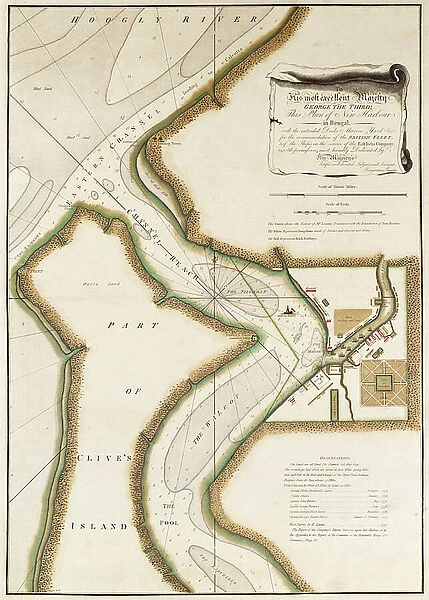
Map of Hoogly River, c.1777 (engraving)
![]()

Wall Art and Photo Gifts from Fine Art Finder
Map of Hoogly River, c.1777 (engraving)
7339428 Map of Hoogly River, c.1777 (engraving) by British School, (18th Century); 20.5x32.5 cm; National Maritime Museum, London, UK; (add.info.: Creator: Lacam, Benjamin
Single sheet. Hand col. engr. Scale: [ca. 1:25 000].
To his most excellent Majesty George the Third; this plan of New Harbour in Bengal with the intended docks marine yards &c. for the accommodation of the British fleet, and of the ships in the service of the East India Company; is, with permission, most humbly dedicated, by his Majesty's dutiful and devoted servant, Benjamin Lacam.); © National Maritime Museum, Greenwich, London
Media ID 38516542
© © National Maritime Museum, Greenwich, London / Bridgeman Images
Bengal Boat Dock Calcutta City Of Calcutta Colony Dock Harbor Area Harbour Area Harbours Pier Pontoons Port Area Quay Quayside Stratagem Strategy West Bengal Wharf 18e Siecle 18th Century 18th Centuries Art Fine Art Asiae Bengalese
FEATURES IN THESE COLLECTIONS
> Europe
> United Kingdom
> Heritage Sites
> Maritime Greenwich
> Fine Art Finder
> Artists
> British School
> Fine Art Finder
> Artists
> Unknown Artist
EDITORS COMMENTS
This engraving from the 18th century showcases a detailed map of the Hoogly River, a vital waterway in Bengal, India. The intricate design and hand-colored elements highlight the strategic importance of this region during colonial times.
Created by Benjamin Lacam, this map was dedicated to King George III as a plan for New Harbour in Bengal, complete with docks, marine yards, and accommodations for both the British fleet and ships of the East India Company. The scale of approximately 1:25,000 allows viewers to appreciate the precision and thought put into this cartographic masterpiece.
The bustling port area depicted in the engraving features piers, docks, quaysides, and boats dotting the riverbanks. This artwork not only serves as a navigational tool but also as a historical record of colonial architecture and infrastructure development in Asia.
As you gaze upon this print from the National Maritime Museum in London, you can't help but be transported back to a time when trade routes were expanding across continents and empires were vying for control over lucrative resources. It's a reminder of how artistry and strategy intersected in shaping global history centuries ago.
MADE IN THE USA
Safe Shipping with 30 Day Money Back Guarantee
FREE PERSONALISATION*
We are proud to offer a range of customisation features including Personalised Captions, Color Filters and Picture Zoom Tools
SECURE PAYMENTS
We happily accept a wide range of payment options so you can pay for the things you need in the way that is most convenient for you
* Options may vary by product and licensing agreement. Zoomed Pictures can be adjusted in the Cart.


