Home > Arts > Artists > A > Battista Agnese
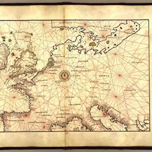
Persia, 1554 (vellum)
")
![]()
Wall Art and Photo Gifts from Fine Art Finder
Persia, 1554 (vellum)
7339640 Persia, 1554 (vellum) by Agnese, Battista (c.1500-64); 26x40 cm; National Maritime Museum, London, UK; (add.info.: Creator: Battista Agnese
Bound sheet. Col. ms. Medium: Vellum. Scale: [ca. 1:75 000 000 (lat)]. Cartographic Note: Latitude scale. Equator divided but not numbered. Additional Places: Indian Ocean. Contents Note: Iconography: winds depicted and labelled in Italian and German; one Portuguese and two Chinese ships; enthroned rulers. Bound in an atlas of twenty-four cartographic items titled: 'Seekarten von Battista Agnese Anno MDLIV.d.IV.May.' The atlas also includes astronomical tables and diagrams. Text in Latin, titles and place names in German outside borders.); © National Maritime Museum, Greenwich, London
Media ID 38372702
© © National Maritime Museum, Greenwich, London / Bridgeman Images
Iran Iranian Iranians Persia Persians
FEATURES IN THESE COLLECTIONS
> Arts
> Artists
> A
> Battista Agnese
> Asia
> Iran
> Related Images
> Europe
> Portugal
> Related Images
> Fine Art Finder
> Artists
> Battista Agnese
> Fine Art Finder
> Artists
> Unknown Artist
EDITORS COMMENTS
This stunning print of Persia from 1554 captures the intricate details and vibrant colors of a map created by Battista Agnese. The map, drawn on vellum, showcases the cartographic skills of Agnese with its precise scale and detailed iconography.
In this piece, we see winds depicted and labeled in both Italian and German, as well as Portuguese and Chinese ships sailing through the Indian Ocean. Enthroned rulers are also featured on the map, adding a touch of regality to the overall composition.
Bound in an atlas titled 'Seekarten von Battista Agnese Anno MDLIV.d.IV.May,' this particular sheet is just one of twenty-four cartographic items included in the collection. The atlas also contains astronomical tables and diagrams, showcasing Agnese's versatility as a cartographer.
Text in Latin accompanies titles and place names written in German outside borders, adding an international flair to this historical piece. This print offers viewers a glimpse into the past, allowing us to appreciate both the artistry and precision that went into creating maps during the 16th century.
Displayed at the National Maritime Museum in London, UK, this print serves as a reminder of Persia's rich history and cultural significance during this time period.
MADE IN THE USA
Safe Shipping with 30 Day Money Back Guarantee
FREE PERSONALISATION*
We are proud to offer a range of customisation features including Personalised Captions, Color Filters and Picture Zoom Tools
SECURE PAYMENTS
We happily accept a wide range of payment options so you can pay for the things you need in the way that is most convenient for you
* Options may vary by product and licensing agreement. Zoomed Pictures can be adjusted in the Cart.