Home > Europe > Belgium > Maps
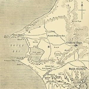
First World War 1914-1918 (War 14-18). Map of the western front between December 1914 and October 1916, German advance - Italian front between June 1915 and October 1916 - extract from the magazine Pays de France no104, 12 October 1916
. Map of the western front between December 1914 and October 1916, German advance - Italian front between June 1915 and October 1916 - extract from the magazine Pays de France no104, 12 October 1916")
![]()
Wall Art and Photo Gifts from Fine Art Finder
First World War 1914-1918 (War 14-18). Map of the western front between December 1914 and October 1916, German advance - Italian front between June 1915 and October 1916 - extract from the magazine Pays de France no104, 12 October 1916
PCT4297712 First World War 1914-1918 (War 14-18). Map of the western front between December 1914 and October 1916, German advance - Italian front between June 1915 and October 1916 - extract from the magazine Pays de France no104, 12 October 1916 -; (add.info.: First World War 1914-1918 (War 14-18). Map of the western front between December 1914 and October 1916, German advance - Italian front between June 1915 and October 1916 - extract from the magazine Pays de France no104, 12 October 1916 -); © Patrice Cartier. All rights reserved 2024
Media ID 38447246
© © Patrice Cartier. All rights reserved 2024 / Bridgeman Images
Beligium Invasion Ww I Battle Field Belgians Belgium Belgian Geographical Map Gusman Iere
FEATURES IN THESE COLLECTIONS
> Arts
> Literature
> Magazines
> Europe
> Belgium
> Related Images
> Fine Art Finder
> Artists
> Unknown photographer
> Historic
> World War I and II
> Battlefields
> Historic
> World War I and II
EDITORS COMMENTS
This print captures a crucial moment in history during the First World War, also known as the Great War. The map depicts the western front between December 1914 and October 1916, showcasing the German advance and the Italian front from June 1915 to October 1916. This extract from the magazine Pays de France no104, dated 12 October 1916, provides a glimpse into the intense battle scenes that unfolded during this tumultuous period.
The detailed engraving highlights key locations such as Belgium and France, where fierce confrontations took place between German forces and Allied troops. The strategic importance of these battlegrounds is evident in this historical document, shedding light on the complexities of warfare during WWI.
As we reflect on this early twentieth-century conflict, it serves as a reminder of the sacrifices made by soldiers from various nations across Europe. The intricate geographical map offers insight into the challenges faced by both sides as they fought for supremacy on land ravaged by war.
Through this powerful image captured by Patrice Cartier, we are transported back in time to witness a pivotal moment in world history that shaped our modern society. Let us remember those who bravely fought during this turbulent era and honor their legacy with gratitude and respect.
MADE IN THE USA
Safe Shipping with 30 Day Money Back Guarantee
FREE PERSONALISATION*
We are proud to offer a range of customisation features including Personalised Captions, Color Filters and Picture Zoom Tools
SECURE PAYMENTS
We happily accept a wide range of payment options so you can pay for the things you need in the way that is most convenient for you
* Options may vary by product and licensing agreement. Zoomed Pictures can be adjusted in the Cart.