Home > North America > United States of America > Maps
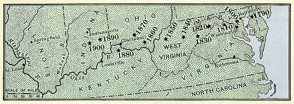
Map showing center of US population moving westward along the National Road, 1790-1900
![]()

Wall Art and Photo Gifts from Fine Art Finder
Map showing center of US population moving westward along the National Road, 1790-1900
NWI4712731 Map showing center of US population moving westward along the National Road, 1790-1900.; (add.info.: Map showing center of US population moving westward along the National Road, 1790-1900.); Photo © North Wind Pictures
Media ID 38269344
© © North Wind Pictures / Bridgeman Images
1790s 1800s 1900 Frontier Heritage Ohio River Old Fashioned Territory Westward Expansion National Pike National Road Old Northwest
FEATURES IN THESE COLLECTIONS
> Fine Art Finder
> Artists
> Unknown photographer
> North America
> United States of America
> Maps
> North America
> United States of America
> Ohio
> Related Images
EDITORS COMMENTS
This print showcases a historical map depicting the movement of the center of US population as it shifted westward along the National Road from 1790 to 1900. The vibrant colors and intricate details bring to life this significant period in American history, illustrating the country's expansion and growth.
As you gaze upon this image, you can almost feel the pioneering spirit that drove settlers to venture into new territories and establish communities along this vital transportation route. The National Road, also known as the National Pike or Turnpike, played a crucial role in connecting the eastern seaboard with the western frontier, facilitating trade and migration across vast distances.
The map captures a snapshot of America's evolution during a time of westward expansion, showcasing how people spread out across the land in search of new opportunities and adventures. From bustling cities to remote settlements, each point on this map tells a story of resilience, determination, and progress.
Through this vintage illustration, we are reminded of our nation's rich heritage and history – a tapestry woven together by countless individuals who dared to dream big and carve out their destinies on the ever-expanding canvas of America. It serves as both a tribute to our past and an inspiration for future generations to continue pushing boundaries and exploring new horizons.
MADE IN THE USA
Safe Shipping with 30 Day Money Back Guarantee
FREE PERSONALISATION*
We are proud to offer a range of customisation features including Personalised Captions, Color Filters and Picture Zoom Tools
SECURE PAYMENTS
We happily accept a wide range of payment options so you can pay for the things you need in the way that is most convenient for you
* Options may vary by product and licensing agreement. Zoomed Pictures can be adjusted in the Cart.


