Home > Animals > Mammals > Asian Lion
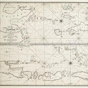
A general chart on Mercators projection to show the track of the Lion and Hindostan from England to the Gulph of Pekin in China and their return back to England, 1796 (print)
")
![]()
Wall Art and Photo Gifts from Fine Art Finder
A general chart on Mercators projection to show the track of the Lion and Hindostan from England to the Gulph of Pekin in China and their return back to England, 1796 (print)
7339422 A general chart on Mercators projection to show the track of the Lion and Hindostan from England to the Gulph of Pekin in China and their return back to England, 1796 (print) by Barrow, John (18th century); 66x100 cm; National Maritime Museum, London, UK; (add.info.: Creator: John Barrow; George Nicol; B Baker
With the daily statement of the barometer and thermometer as observed at noon containing also the limits of the Chinese Empire as extended by the conquests of the present Emperor Tchien-Lung.); © National Maritime Museum, Greenwich, London
Media ID 38519860
© © National Maritime Museum, Greenwich, London / Bridgeman Images
FEATURES IN THESE COLLECTIONS
> Animals
> Mammals
> Asian Lion
> Arts
> Artists
> B
> George Baker
> Arts
> Artists
> B
> George Back
> Arts
> Artists
> W
> George White
> Arts
> Artists
> W
> John White
> Europe
> Republic of Ireland
> Maps
> Europe
> United Kingdom
> England
> London
> Boroughs
> Greenwich
> Europe
> United Kingdom
> England
> London
> Museums
> British Museum
> Fine Art Finder
> Artists
> William Heather
EDITORS COMMENTS
This stunning print showcases a general chart on Mercator's projection, illustrating the track of the 'Lion' and 'Hindostan' ships as they journeyed from England to the Gulph of Pekin in China and back again in 1796. Created by John Barrow, George Nicol, and B Baker, this historical piece measures 66x100 cm and is housed at the National Maritime Museum in London.
The intricate details on the map include daily readings of the barometer and thermometer taken at noon, providing a fascinating insight into the conditions experienced during this epic voyage. Additionally, it outlines the limits of the Chinese Empire as extended by Emperor Tchien-Lung's conquests.
As you study this map, you can't help but be transported back to a time when exploration and discovery were at their peak. The meticulous craftsmanship and attention to detail are evident in every line drawn on this piece of art.
Whether you're a history buff or simply appreciate fine cartography, this print is sure to captivate your imagination. It serves as a reminder of humanity's insatiable curiosity and drive to explore new horizons, making it a timeless addition to any collection.
MADE IN THE USA
Safe Shipping with 30 Day Money Back Guarantee
FREE PERSONALISATION*
We are proud to offer a range of customisation features including Personalised Captions, Color Filters and Picture Zoom Tools
SECURE PAYMENTS
We happily accept a wide range of payment options so you can pay for the things you need in the way that is most convenient for you
* Options may vary by product and licensing agreement. Zoomed Pictures can be adjusted in the Cart.