Home > Animals > Mammals > Didelphidae > Formosa
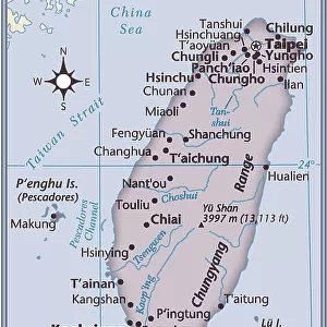
Map of the Liu-Kiu Islands and Formosa, c.1900 (engraving)
")
![]()
Wall Art and Photo Gifts from Fine Art Finder
Map of the Liu-Kiu Islands and Formosa, c.1900 (engraving)
533335 Map of the Liu-Kiu Islands and Formosa, c.1900 (engraving); (add.info.: Historical map of Southern part of Japan, Liu-Kiu Islands and Formosa with inset map of Bonin and Sulphur Islands, circa 1902, from the 10th edition of Encyclopaedia Britannica.); Encyclopaedia Britannica/UIG
Media ID 38309852
© Encyclopaedia Britannica/UIG / Bridgeman Images
1902 19th Century Style Archipelago Cut Out Formosa Guidance Illustration Technique Meridian Navigational Equipment Old Fashioned Pacific Ocean Physical Geography Ryukyu Islands Taiwan The Past Western Script White Background
FEATURES IN THESE COLLECTIONS
> Animals
> Mammals
> Didelphidae
> Formosa
> Asia
> Taiwan
> Related Images
> Fine Art Finder
> Temp Classification
> Maps and Charts
> Early Maps
EDITORS COMMENTS
This stunning engraving from c.1900 showcases a historical map of the Liu-Kiu Islands and Formosa, providing a glimpse into the intricate cartography of the time. The detailed depiction includes the southern part of Japan, with inset maps of Bonin and Sulphur Islands, offering a comprehensive view of this region in Asia.
The delicate lines and Western script on the map reflect the artistry and precision that went into creating navigational tools for exploration and conflict during this era. The archipelago's coastlines, meridians, and volcanic islands are meticulously illustrated, highlighting both physical geography and historical significance.
As we gaze upon this piece, we are transported back to a time when maps were not just tools for guidance but also windows into distant lands and cultures. The map evokes a sense of wonder about past explorations across the Pacific Ocean, shedding light on the rich history of these islands.
With no people present in the image, we are left to marvel at the intricacies of this old-fashioned illustration technique that captures both beauty and functionality. This print is not just a representation of geographical knowledge but also a work of art that continues to fascinate viewers with its timeless appeal.
MADE IN THE USA
Safe Shipping with 30 Day Money Back Guarantee
FREE PERSONALISATION*
We are proud to offer a range of customisation features including Personalised Captions, Color Filters and Picture Zoom Tools
SECURE PAYMENTS
We happily accept a wide range of payment options so you can pay for the things you need in the way that is most convenient for you
* Options may vary by product and licensing agreement. Zoomed Pictures can be adjusted in the Cart.