Home > Asia > Singapore > Maps
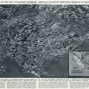
Map of the Malay Peninsula, c.1900 (engraving)
")
![]()
Wall Art and Photo Gifts from Fine Art Finder
Map of the Malay Peninsula, c.1900 (engraving)
533325 Map of the Malay Peninsula, c.1900 (engraving); (add.info.: Map showing historical boundaries of the Malay Peninsula, Sumatra, and Singapore, circa 1902, from the 10th edition of Encyclopaedia Britannica.); Encyclopaedia Britannica/UIG
Media ID 38406184
© Encyclopaedia Britannica/UIG / Bridgeman Images
1902 19th Century Style Boundary Guidance Illustration Technique Malay Peninsula Meridian Navigational Equipment Old Fashioned Peninsula Physical Geography Republic Of Singapore Singapore Singapore Island Singaporean Singaporeans South China Sea South East Asia Sumatra The Past Western Script Andaman Sea
FEATURES IN THESE COLLECTIONS
> Asia
> Singapore
> Singapore
> Fine Art Finder
> Temp Classification
> Maps and Charts
> Early Maps
EDITORS COMMENTS
This stunning engraving of a Map of the Malay Peninsula, circa 1900, offers a fascinating glimpse into the historical boundaries and geographical features of this region. The intricate details on the map showcase the coastlines, boundaries, and navigational elements that were crucial for exploration and trade in Southeast Asia during this time period.
The inclusion of Sumatra and Singapore on the map highlights their significance as key locations within the Malay Peninsula. The Western script used for labeling adds to the old-fashioned charm of this piece, evoking a sense of nostalgia for a bygone era.
As we study this map, we are transported back to a time when cartography played a vital role in guiding travelers across land and sea. The meridians marking out different regions remind us of the importance of accurate mapping for navigation purposes.
This print from Fine Art Finder is not just a visual representation but also serves as a historical document that captures the essence of exploration and discovery in Southeast Asia at the turn of the 20th century. It is truly a testament to human ingenuity and curiosity about our world's physical geography.
MADE IN THE USA
Safe Shipping with 30 Day Money Back Guarantee
FREE PERSONALISATION*
We are proud to offer a range of customisation features including Personalised Captions, Color Filters and Picture Zoom Tools
SECURE PAYMENTS
We happily accept a wide range of payment options so you can pay for the things you need in the way that is most convenient for you
* Options may vary by product and licensing agreement. Zoomed Pictures can be adjusted in the Cart.