Home > Europe > Finland > Maps
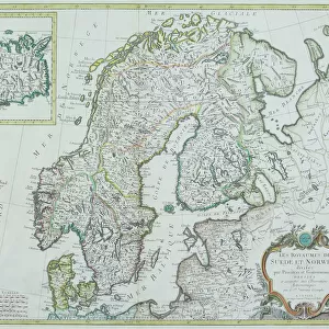
Map of Russia showing historical boundaries of Russia in Europe with Poland and Finland, circa 1902

![]()
Wall Art and Photo Gifts from Fine Art Finder
Map of Russia showing historical boundaries of Russia in Europe with Poland and Finland, circa 1902
532992 Map of Russia showing historical boundaries of Russia in Europe with Poland and Finland, circa 1902; (add.info.: Map showing historical boundaries of Russia in Europe with Poland and Finland, circa 1902, from the 10th edition of Encyclopaedia Britannica.); Encyclopaedia Britannica/UIG
Media ID 38309838
© Encyclopaedia Britannica/UIG / Bridgeman Images
1902 19th Century Style Boundary Finland Geographical Border Guidance Illustration Technique Meridian Navigational Equipment Old Fashioned Part Of Physical Geography Poland Poland Polish Pole Polish The Past Western Script
FEATURES IN THESE COLLECTIONS
> Europe
> Finland
> Paintings
> Europe
> Finland
> Related Images
> Europe
> Poland
> Related Images
> Fine Art Finder
> Temp Classification
EDITORS COMMENTS
This stunning vintage print showcases a Map of Russia from circa 1902, highlighting the historical boundaries of Russia in Europe with Poland and Finland. The intricate details of this map, taken from the 10th edition of Encyclopaedia Britannica, offer a glimpse into the past and provide valuable insight into the geopolitical landscape of that time.
The borders depicted on this map tell a story of conquests, alliances, and territorial disputes that have shaped the history of Europe and Asia. From the western script labeling to the navigational equipment symbols scattered throughout, every element on this map serves as a reminder of an era long gone but not forgotten.
As you study this piece closely, you can almost feel yourself transported back in time to an age when cartography was both an art form and a science. The careful delineation of coastlines, boundaries, meridians, and geographical features speaks to the meticulous attention to detail that went into creating maps like these.
Whether you are a history buff or simply appreciate fine craftsmanship, this Map of Russia is sure to captivate your imagination and spark your curiosity about the events that have shaped our world.
MADE IN THE USA
Safe Shipping with 30 Day Money Back Guarantee
FREE PERSONALISATION*
We are proud to offer a range of customisation features including Personalised Captions, Color Filters and Picture Zoom Tools
SECURE PAYMENTS
We happily accept a wide range of payment options so you can pay for the things you need in the way that is most convenient for you
* Options may vary by product and licensing agreement. Zoomed Pictures can be adjusted in the Cart.