Home > Oceania > Solomon Islands > Maps
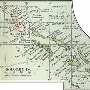
Map of Solomon Islands, c.1900 (engraving)
")
![]()
Wall Art and Photo Gifts from Fine Art Finder
Map of Solomon Islands, c.1900 (engraving)
533372 Map of Solomon Islands, c.1900 (engraving); (add.info.: Map of Solomon Islands, Bougainville, South Pacific, circa 1902, from the 10th edition of Encyclopaedia Britannica.); Encyclopaedia Britannica/UIG
Media ID 38453944
© Encyclopaedia Britannica/UIG / Bridgeman Images
1902 19th Century Style Archipelago Cut Out Guidance Illustration Technique Meridian Navigational Equipment Number Old Fashioned Physical Geography Solomon Islands South Pacific Ocean The Past Western Script White Background
FEATURES IN THESE COLLECTIONS
> Fine Art Finder
> Temp Classification
> Oceania
> Solomon Islands
> Maps
> Oceania
> Solomon Islands
> Related Images
EDITORS COMMENTS
This stunning engraving of a Map of Solomon Islands, circa 1900, offers a glimpse into the intricate cartography of the South Pacific archipelago during the late 19th century. The detailed map, originally featured in the 10th edition of Encyclopaedia Britannica, showcases Bougainville Island and surrounding areas with Western script labels and navigational equipment symbols.
The old-fashioned style of this historical map evokes a sense of exploration and discovery from a bygone era. The carefully drawn meridians and sea routes provide valuable guidance for sailors and explorers navigating through the vast expanse of the South Pacific Ocean.
As we gaze upon this illustration on a white background, we are transported back in time to an age when maps were essential tools for understanding the physical geography of distant lands. The intricate details and precise numbering on this map reflect the meticulous craftsmanship that went into creating such works of art.
This print serves as a reminder of our rich history and heritage, capturing a moment in time when cartographers painstakingly charted uncharted territories for future generations to explore. It is not just a piece of artwork but also a window into our past, showcasing the beauty and complexity of one small corner of our world.
MADE IN THE USA
Safe Shipping with 30 Day Money Back Guarantee
FREE PERSONALISATION*
We are proud to offer a range of customisation features including Personalised Captions, Color Filters and Picture Zoom Tools
SECURE PAYMENTS
We happily accept a wide range of payment options so you can pay for the things you need in the way that is most convenient for you
* Options may vary by product and licensing agreement. Zoomed Pictures can be adjusted in the Cart.