Fine Art Print > Europe > France > Canton > Charente
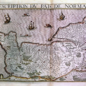
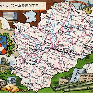
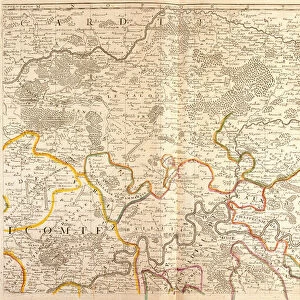
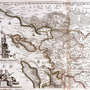
Fine Art Print : Map of Poitou Charentes (France) (Engraving, 1717)
 (Engraving, 1717)")


![]()
Fine Art Prints from Fine Art Finder
Map of Poitou Charentes (France) (Engraving, 1717)
LRI4711769 Map of Poitou Charentes (France) (Engraving, 1717) by Nolin, Jean-Baptiste (c.1657-1708); Private Collection; (add.info.: Map of the generality of La Rochelle, with the land of Aunis and Saintonge (Poitou Charentes) - Engraving from the atlas le theatre du monde, 1717, by Jean Baptiste Nolin (1686-1762) - Map of Poitou Charentes (France) - From " Le Theatre du Monde" 1717 by Jean-Baptiste Nolin); Luisa Ricciarini; French, out of copyright
Media ID 23717816
© Luisa Ricciarini / Bridgeman Images
Atlas Book Chestle Geographical Map
21"x14" (+3" Border) Fine Art Print
Discover the rich history and culture of Poitou-Charentes, France, with this exquisite 1717 engraved map from the Media Storehouse Fine Art Prints collection. Created by Jean-Baptiste Nolin, this rare and intricately detailed map showcases the generality of La Rochelle during the early 18th century. Bring the elegance and sophistication of Old World cartography into your home or office with this beautiful, archival-quality print from Fine Art Finder by Luisa Ricciarini. A perfect addition to any decor, this map is not only a work of art but also a historical treasure.
21x14 image printed on 27x20 Fine Art Rag Paper with 3" (76mm) white border. Our Fine Art Prints are printed on 300gsm 100% acid free, PH neutral paper with archival properties. This printing method is used by museums and art collections to exhibit photographs and art reproductions.
Our fine art prints are high-quality prints made using a paper called Photo Rag. This 100% cotton rag fibre paper is known for its exceptional image sharpness, rich colors, and high level of detail, making it a popular choice for professional photographers and artists. Photo rag paper is our clear recommendation for a fine art paper print. If you can afford to spend more on a higher quality paper, then Photo Rag is our clear recommendation for a fine art paper print.
Estimated Image Size (if not cropped) is 53.3cm x 31cm (21" x 12.2")
Estimated Product Size is 68.6cm x 50.8cm (27" x 20")
These are individually made so all sizes are approximate
Artwork printed orientated as per the preview above, with landscape (horizontal) orientation to match the source image.
FEATURES IN THESE COLLECTIONS
> Fine Art Finder
> Artists
> Anonymous
> Fine Art Finder
> Artists
> Jean-Baptiste Nolin
> Europe
> France
> Canton
> Charente
> Europe
> France
> Canton
> Landes
> Maps and Charts
> Related Images
EDITORS COMMENTS
This print showcases a remarkable piece of history - the "Map of Poitou Charentes (France)" from 1717. Created by the talented engraver Jean-Baptiste Nolin, this map is an exquisite representation of the generality of La Rochelle, along with the regions of Aunis and Saintonge in Poitou Charentes. Part of Nolin's renowned atlas "Le Theatre du Monde" this engraving beautifully captures the intricate details and geographical features of the area. The map offers a glimpse into France's past, allowing us to explore its rich heritage and understand how these regions were connected during that time. Luisa Ricciarini has skillfully preserved this historical gem through her expertly crafted photo print. With every line and contour faithfully reproduced, viewers can appreciate both the artistry involved in creating such maps as well as their practical significance for navigation and understanding land boundaries. As we gaze upon this enchanting artwork, we are transported back to 18th-century France - a time when cartography was not only a scientific pursuit but also an artistic endeavor. This print serves as a testament to human curiosity about our surroundings and our desire to document them for future generations. With its timeless beauty and historical significance, this print is sure to captivate anyone with an appreciation for geography, French culture, or simply those who seek to be inspired by centuries-old craftsmanship.
MADE IN THE USA
Safe Shipping with 30 Day Money Back Guarantee
FREE PERSONALISATION*
We are proud to offer a range of customisation features including Personalised Captions, Color Filters and Picture Zoom Tools
SECURE PAYMENTS
We happily accept a wide range of payment options so you can pay for the things you need in the way that is most convenient for you
* Options may vary by product and licensing agreement. Zoomed Pictures can be adjusted in the Cart.