Fine Art Print > Europe > Croatia > Maps
Fine Art Print : Universal Geography: Yugoslavia (Kingdom of Serbs, Croats and Slovenes). Advertising images edited for the brand Louit. Debut 20th century. (lithograph)
. Advertising images edited for the brand Louit. Debut 20th century. (lithograph)")


![]()
Fine Art Prints from Fine Art Finder
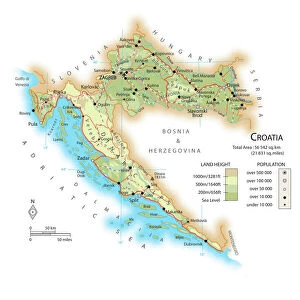
Universal Geography: Yugoslavia (Kingdom of Serbs, Croats and Slovenes). Advertising images edited for the brand Louit. Debut 20th century. (lithograph)
DUV4218137 Universal Geography: Yugoslavia (Kingdom of Serbs, Croats and Slovenes). Advertising images edited for the brand Louit. Debut 20th century. (lithograph); 9.5x6.5 cm; Photo © Duvallon
Media ID 38327280
© © Duvallon / Bridgeman Images
Blazon Coat Of Arm Coat Or Arms Heraldic Yugoslavia Yugoslavian Geographer Geographical Map Heraldry
20"x16" (+3" Border) Fine Art Print
Discover the beauty of historical lithographs with our Fine Art Prints collection, featuring "Universal Geography: Yugoslavia" by Bridgeman Images. This stunning piece captures the essence of the Kingdom of Serbs, Croats and Slovenes in the early 20th century. Perfect for adding a touch of vintage charm to any space.
20x16 image printed on 26x22 Fine Art Rag Paper with 3" (76mm) white border. Our Fine Art Prints are printed on 300gsm 100% acid free, PH neutral paper with archival properties. This printing method is used by museums and art collections to exhibit photographs and art reproductions.
Our fine art prints are high-quality prints made using a paper called Photo Rag. This 100% cotton rag fibre paper is known for its exceptional image sharpness, rich colors, and high level of detail, making it a popular choice for professional photographers and artists. Photo rag paper is our clear recommendation for a fine art paper print. If you can afford to spend more on a higher quality paper, then Photo Rag is our clear recommendation for a fine art paper print.
Estimated Image Size (if not cropped) is 40.6cm x 46.3cm (16" x 18.2")
Estimated Product Size is 55.9cm x 66cm (22" x 26")
These are individually made so all sizes are approximate
Artwork printed orientated as per the preview above, with portrait (vertical) orientation to match the source image.
FEATURES IN THESE COLLECTIONS
> Fine Art Finder
> Artists
> Benjamin Rabier
> Europe
> Croatia
> Related Images
> Europe
> Serbia
> Related Images
> Maps and Charts
> Early Maps
> Maps and Charts
> Related Images
EDITORS COMMENTS
Step back in time with this stunning lithograph print of Universal Geography: Yugoslavia from the early 20th century. The Kingdom of Serbs, Croats, and Slovenes is beautifully depicted in intricate detail, showcasing the diverse regions that make up this historic European country.
Edited for the brand Louit, this image captures the essence of a bygone era when cartography was both an art form and a scientific pursuit. The coat of arms proudly displayed on the map adds a regal touch to the overall composition, highlighting the rich history and heritage of Yugoslavia.
As you gaze upon this piece, you can almost envision geographers meticulously mapping out each region, capturing its unique features and landmarks. The attention to detail is truly remarkable, making it a captivating piece for any history buff or geography enthusiast.
Whether you have a personal connection to Yugoslavia or simply appreciate fine art from the past, this lithograph print is sure to spark your curiosity and imagination. Transport yourself back in time to explore the geographical wonders of this fascinating country through the lens of an early 20th-century artist.
MADE IN THE USA
Safe Shipping with 30 Day Money Back Guarantee
FREE PERSONALISATION*
We are proud to offer a range of customisation features including Personalised Captions, Color Filters and Picture Zoom Tools
SECURE PAYMENTS
We happily accept a wide range of payment options so you can pay for the things you need in the way that is most convenient for you
* Options may vary by product and licensing agreement. Zoomed Pictures can be adjusted in the Cart.