Fine Art Print > North America > United States of America > Massachusetts > Cambridge
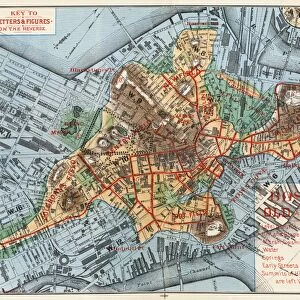
Fine Art Print : Map of Boston, Massachusetts, Charlestown, Cambridge, Dorchester, and Vicinity, 1775. Coloured water, 19th century


![]()
Fine Art Prints from Fine Art Finder
Map of Boston, Massachusetts, Charlestown, Cambridge, Dorchester, and Vicinity, 1775. Coloured water, 19th century
NWI4841059 Map of Boston, Massachusetts, Charlestown, Cambridge, Dorchester, and Vicinity, 1775. Coloured water, 19th century.; (add.info.: Map of Boston, Massachusetts, Charlestown, Cambridge, Dorchester, and Vicinity, 1775. Coloured water, 19th century.); Photo © North Wind Pictures
Media ID 38430538
© © North Wind Pictures / Bridgeman Images
20"x16" (+3" Border) Fine Art Print
Explore the rich history of Boston with this stunning Fine Art Print depicting a map from 1775. Perfect for adding a touch of vintage charm to any space.
20x16 image printed on 26x22 Fine Art Rag Paper with 3" (76mm) white border. Our Fine Art Prints are printed on 300gsm 100% acid free, PH neutral paper with archival properties. This printing method is used by museums and art collections to exhibit photographs and art reproductions.
Our fine art prints are high-quality prints made using a paper called Photo Rag. This 100% cotton rag fibre paper is known for its exceptional image sharpness, rich colors, and high level of detail, making it a popular choice for professional photographers and artists. Photo rag paper is our clear recommendation for a fine art paper print. If you can afford to spend more on a higher quality paper, then Photo Rag is our clear recommendation for a fine art paper print.
Estimated Image Size (if not cropped) is 50.8cm x 37.4cm (20" x 14.7")
Estimated Product Size is 66cm x 55.9cm (26" x 22")
These are individually made so all sizes are approximate
Artwork printed orientated as per the preview above, with landscape (horizontal) orientation to match the source image.
FEATURES IN THESE COLLECTIONS
> Fine Art Finder
> Artists
> Butler and Bayne (workshop) Heaton
> Maps and Charts
> Early Maps
> Maps and Charts
> Related Images
> North America
> United States of America
> Maps
> North America
> United States of America
> Massachusetts
> Boston
> North America
> United States of America
> Massachusetts
> Cambridge
> North America
> United States of America
> Massachusetts
> Related Images
EDITORS COMMENTS
This stunning print captures a beautifully detailed map of Boston, Massachusetts, Charlestown, Cambridge, Dorchester, and Vicinity from the year 1775. The vibrant colors used in this 19th-century reproduction bring to life the intricate details of this historical map.
As you study the map closely, you can see the layout of the city during that time period, with each neighborhood clearly labeled and defined. The streets are intricately drawn out, showcasing the early urban planning of Boston in the late 18th century.
The inclusion of Charlestown, Cambridge, and Dorchester on this map provides a comprehensive view of not just Boston itself but also its surrounding areas. This gives us a glimpse into what life may have been like for residents living in these communities over two centuries ago.
The engraving technique used to create this map adds an element of artistry to its historical significance. It serves as both a practical tool for understanding geography and as a beautiful piece of artwork that would be at home displayed in any history buff's collection.
Overall, this print is not just a visual representation of Boston's past but also a reminder of how far we've come since those early days in America's history.
MADE IN THE USA
Safe Shipping with 30 Day Money Back Guarantee
FREE PERSONALISATION*
We are proud to offer a range of customisation features including Personalised Captions, Color Filters and Picture Zoom Tools
SECURE PAYMENTS
We happily accept a wide range of payment options so you can pay for the things you need in the way that is most convenient for you
* Options may vary by product and licensing agreement. Zoomed Pictures can be adjusted in the Cart.