Fine Art Print > Arts > Artists > C > Vincenzo Maria Coronelli
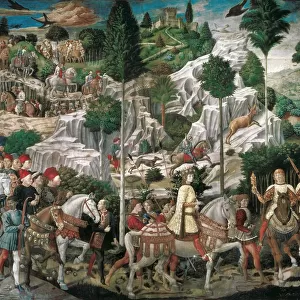
Fine Art Print : Map of the northern Mexican archipelago and the West Indies, 1688 (engraving)
")


![]()
Fine Art Prints from Fine Art Finder
Map of the northern Mexican archipelago and the West Indies, 1688 (engraving)
VNK284160 Map of the northern Mexican archipelago and the West Indies, 1688 (engraving) by Coronelli, Vincenzo Maria (1650-1718); Vorontsov Palace, Crimea, Ukraine; (add.info.: Published in Paris in 1688; the elaborately embellished cartouche shows plants, animals, and natives of the region.
By Vincenzo Maria Coronelli, Italian cartographer); © Vadim Nekrasov
Media ID 33069134
© © Vadim Nekrasov / Bridgeman Images
Art Fine Art British West Indies Caribbean Caribbean Island Central America Coast Line Cuba Cuba Cuban Cuban Cubans Dominican Republic Haiti Haitian Islands Isles Jamaica Jamaica Jamaican Jamaican Jamaicans Mexicans Mexico Mexican New World Puerto Rico Puertorican Puertoricans Shorelines West Indies 17th Centuries America Continent Geographer Seawater
20"x16" (+3" Border) Fine Art Print
Discover the rich history of cartography with this stunning Fine Art Print of the Map of the Northern Mexican Archipelago and the West Indies, engraved in 1688 by Vincenzo Maria Coronelli. This intricately detailed map, copyrighted by Vadim Nekrasov from Fine Art Finder, showcases the cartographic knowledge of the time, featuring the West Indies and the Northern Mexican Archipelago. A beautiful addition to any home or office, this print is a testament to the fascination and exploration of the New World. Hang it up and let the stories of the past unfold.
20x16 image printed on 26x22 Fine Art Rag Paper with 3" (76mm) white border. Our Fine Art Prints are printed on 300gsm 100% acid free, PH neutral paper with archival properties. This printing method is used by museums and art collections to exhibit photographs and art reproductions.
Our fine art prints are high-quality prints made using a paper called Photo Rag. This 100% cotton rag fibre paper is known for its exceptional image sharpness, rich colors, and high level of detail, making it a popular choice for professional photographers and artists. Photo rag paper is our clear recommendation for a fine art paper print. If you can afford to spend more on a higher quality paper, then Photo Rag is our clear recommendation for a fine art paper print.
Estimated Image Size (if not cropped) is 50.8cm x 37.5cm (20" x 14.8")
Estimated Product Size is 66cm x 55.9cm (26" x 22")
These are individually made so all sizes are approximate
Artwork printed orientated as per the preview above, with landscape (horizontal) orientation to match the source image.
FEATURES IN THESE COLLECTIONS
> Fine Art Finder
> Artists
> Vincenzo Maria Coronelli
> Fine Art Finder
> Maps (celestial & Terrestrial)
> Arts
> Artists
> C
> Vincenzo Maria Coronelli
> Arts
> Artists
> O
> Oceanic Oceanic
> Europe
> France
> Paris
> Maps
> Europe
> Ukraine
> Related Images
EDITORS COMMENTS
This print showcases a remarkable engraving from 1688, titled "Map of the northern Mexican archipelago and the West Indies". Created by Vincenzo Maria Coronelli, an esteemed Italian cartographer, this map offers a fascinating glimpse into the geography of Central America during the seventeenth century. The intricately detailed cartouche steals the spotlight with its elaborate embellishments depicting plants, animals, and natives indigenous to the region. Published in Paris in 1688, this masterpiece is a testament to Coronelli's exceptional skill and artistry. The vibrant colors bring life to this historical artwork, allowing us to envision what these lands may have looked like centuries ago. From Cuba and Jamaica to Haiti and beyond, each island is meticulously depicted within this enchanting composition. As we explore every inch of this map's coastal lines and contours, we are transported back in time to an era when European explorers were just beginning their journeys across uncharted territories. It serves as a reminder of how far our understanding of geography has come since then. Preserved through Vadim Nekrasov's lens, this print captures not only a work of art but also a valuable piece of history. It invites us to appreciate both the beauty inherent in maps as well as their significance in shaping our understanding of different cultures and landscapes throughout time.
MADE IN THE USA
Safe Shipping with 30 Day Money Back Guarantee
FREE PERSONALISATION*
We are proud to offer a range of customisation features including Personalised Captions, Color Filters and Picture Zoom Tools
SECURE PAYMENTS
We happily accept a wide range of payment options so you can pay for the things you need in the way that is most convenient for you
* Options may vary by product and licensing agreement. Zoomed Pictures can be adjusted in the Cart.